Onshore southerly swells to end the week
Southern Tasmania Surf Forecast by Craig Brokensha (issued Wednesday 29th May)
Best Days: Protected spots Friday, Saturday, Sunday morning
Recap
A small pulse of W/SW swell yesterday to 1-2ft, but a better building W/SW groundswell today was around a clean 2ft this morning, with the size expected to reach 3ft+ this afternoon but with poor conditions with this W/SW change.
Today’s Forecaster Notes are brought to you by Rip Curl
This week and weekend (May 30 – Jun 2)
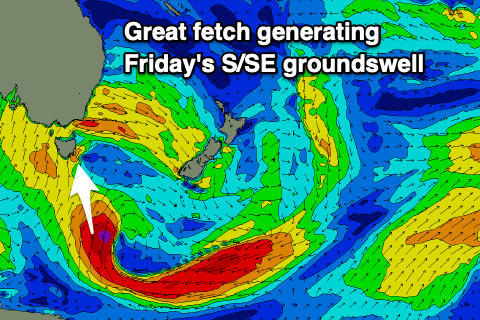
Today's onshore change is linked to the vigorous frontal progression that's been positioned to our west moving slowly to the east, opening our region to a strong local S/SW fetch and polar gale to severe-gale S/SE winds to the south-southeast of the state.
We'll see the W/SW groundswell from today easing with new mid-period S/SW energy to 3ft+ across Clifton but with onshore W/SW winds.
 A stronger S/SE groundswell should be off the polar fetch, providing solid 4-5ft sets across Clifton through the day Friday, easing later in the day. The eating trend will be slowed by a fetch of S'ly gales persisting in our southern swell window into tomorrow, shifting away from us into the evening.
Saturday morning should still be 3ft+, easing into the afternoon and smaller Sunday from 2ft.
Conditions will unfortunately remain onshore Friday with a fresh and gusty SW wind, better Saturday with a W/NW-NW offshore persisting most if not all of the day.
Sunday should be clean with a N/NW offshore, giving into a W/SW change into the afternoon.
This change will be linked to a strengthening low moving across us, bringing strong S'ly winds on Monday and a poor increase in S'ly windswell with onshore S/SW winds. Following this there's nothing too significant on the cards so try and work the S'ly swell and winds at the end of the week.

