Fun S/SE swell for the weekend, tiny thereafter
Southern Tasmania Surf Forecast by Craig Brokensha (issued Friday 19th April)
Best Days: Saturday, beginners Monday morning, later week
Recap
A continuation of tiny surf yesterday, while today our new W/SW swell has filled in on forecast with clean fun 2ft sets.
Today’s Forecaster Notes are brought to you by Rip Curl
This weekend and next week (Apr 20 - 26)
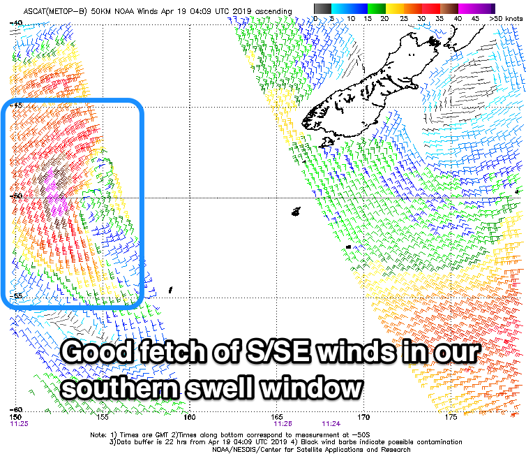
Today's W/SW swell will fade away through tomorrow, but a new S/SE swell from a tight low that formed south-southeast of us yesterday is still on track.
 This low generated a fetch of S-S/SE gales with satellite observations confirming the fetch was within our swell window, and we should see the swell kicking this afternoon, peaking tomorrow morning to what now looks to be 2-3ft across Clifton on the sets.
A rapid drop in size is due though, so get out in the morning for all the action, with Sunday being tiny.
Winds will be straight from the N'th tomorrow morning, tending N/NE through the day as the swell eases.
As touched on last update there's nothing significant on the cards for early-mid next week.
A very intense low forming south of the Bight will generate a great fetch of severe-gale to storm-force W'ly winds, but too far north of our swell window and once it drifts south into our swell window it will be much weaker. Any size from this low looks to only be to 1ft Monday with NW tending SW winds.
Longer term we'll see the westerly storm track strengthen west of us and aim back to back frontal systems across and under us mid-late next week.
This should produce some better W/SW groundswell from later week and into next weekend, but we'll have another look at this Monday. Have a happy and safe Easter!

