Strong easing swell towards the weekend
Southern Tasmania Surf Forecast by Craig Brokensha (issued Monday 7th January)
Best Days: Tuesday morning, Wednesday, Thursday morning
Recap
Tiny waves to start Saturday but a small kick in size was seen into the afternoon, clean and easing yesterday.
Today started small and clean but a strong long-period SW groundswell has since jumped quite significantly off Cape Sorell and we should be seeing solid sets pushing into the South Arm this afternoon and evening.
Today’s Forecaster Notes are brought to you by Rip Curl
This week and weekend (Jan 8 - 13)
The polar low linked to today's strong increase in SW groundswell moved under us this morning and is now moving off further to the east. We'll see the swell peak overnight and ease back quickly from a solid 3-4ft tomorrow morning with a light NW offshore, giving into afternoon SE sea breezes.
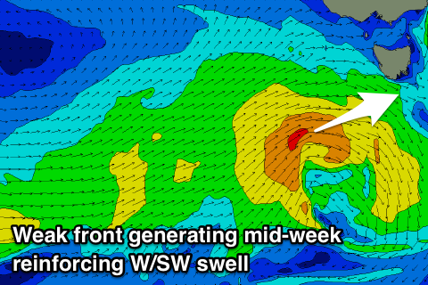
 Wednesday is looking much smaller with 2ft leftovers, but a small mid-period W/SW swell should stem the easing trend, generated by a small front moving in from the west today and tomorrow.
A secondary weak front firing up on the tail of this initial front should keep 2ft sets hitting Clifton into Thursday morning before easing off into the afternoon, tiny into Friday and the weekend.
Winds on Wednesday look favourable early with a W/NW breeze, possible tending W/SW mid-morning but then veering back to the W/NW through the day with the next approaching front. Thursday looks good with a W/NW offshore holding most of the morning.
Unfortunately there's nothing too significant at all on the cards until early next week when we may see a small SW groundswell, but more on this Wednesday.

