Increasing swell energy from mid-week
Southern Tasmania Surf Forecast by Craig Brokensha (issued Monday 31st December)
Best Days: Wednesday morning, Thursday, early Friday keen surfers
Recap
Tricky west swells over the weekend and today with a tiny lift in swell Saturday as the diciest of the bunch filled in, with a little more size yesterday, back to a tiny 1ft this morning.
A new W/SW swell should be kicking the swell up to 2ft during this afternoon but sea breezes are now in and creating average conditions.
Today’s Forecaster Notes are brought to you by Rip Curl
This week and weekend (Jan 1 - 6)
We've got much more reliable swell energy on the cards for the coming week, with any size seen this afternoon due to fade into tomorrow morning, with building surf from dark tomorrow, but more so Wednesday.
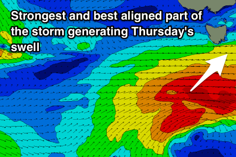
An elongated fetch of strong W/SW winds are currently pushing in from the west and will move under the state tomorrow afternoon and evening, with stronger gale-force W/SW winds on its tail.
This gale-force fetch will be slow moving and persist in our swell window through Wednesday before continuing east Thursday.
 A dicey and mid-period W/SW swell is due to fill in Wednesday ahead of a late kick in stronger W/SW groundswell, peaking Thursday morning.
Clifton looks to build to slowly towards 2-3ft on Wednesday afternoon, with Thursday morning seeing more consistent 3ft sets, easing off slowly and back from a smaller 1-2ft Friday.
Winds on Wednesday morning look OK and out of the W/NW but the swell on the smaller side, with W/SW breezes into the afternoon, while Thursday should provide plenty of options with a N/NW tending NE breeze.
Friday looks OK with an early N/NE breeze ahead of a late morning SW change.
The change will be linked with an east-southeast tracking mid-latitude low pushing in from the west, with a late burst of W'ly gales due to be generated in our western swell window.
A small spike in swell to 1-2ft is due through the day Saturday, but very west in nature and with dicey winds.
Longer term a strong SW groundswell is on the cards next week as a very intense storms develops along the polar shelf, but more on this Wednesday. Happy New Year!

