Tiny swell pulses ahead of stronger swells next week
Southern Tasmania Surf Forecast by Craig Brokensha (issued Wednesday 28th November)
Best Days: Beginners Friday and Saturday mornings, Monday morning, Tuesday morning
Recap
Average easing and sloppy levels of SE swell yesterday, tiny today.
Today’s Forecaster Notes are brought to you by Rip Curl
This week and weekend (Nov 29 – Dec 2)
Tiny surf will continue tomorrow ahead of our tiny W/SW swell into Friday and secondary similar size and more W'ly pulse for Saturday.
The first swell was generated at more polar latitudes but by a weaker storm, though we should see 1-1.5ft sets with a light NW offshore wind ahead of SE sea breezes.
 The secondary swell was generated by a stronger but more northerly positioned storm and as a result I'd expect less consistent 1-1.5ft waves when it peaks on Saturday morning but with a nice morning NW offshore again, strengthening from the N'th through the day as the swell eases.
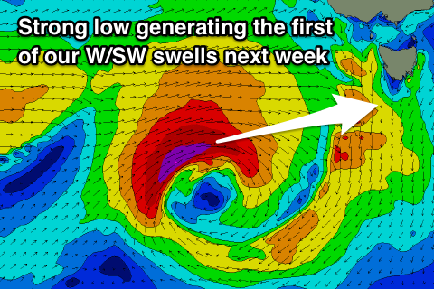
Moving into next week we'll see a flurry of strong storms developing in the Southern Ocean under the influence of a strong node of the Long Wave Trough in the Bight.
An initial intense low will track just within our swell window, producing a fetch of severe-gale W'ly winds, but it's due to stall west of us and dip slightly east-southeast and more into our swell window.
This should produce a moderate sized W/SW groundswell for possibly late Sunday and more so Monday morning to 3ft across Clifton.
We'll see another strong polar front spawning off the back of the original low, generating an additional W/SW swell for Tuesday morning that looks to come in at 3-4ft.
With all the localised activity, winds on Monday will be strong out of the W/NW, shifting W/SW through the day, back to the W/NW Tuesday. More on this Friday though.

