Fading SE swell with small westerly pulses from Friday
Southern Tasmania Surf Forecast by Craig Brokensha (issued Monday 26th November)
Best Days: Friday morning, early Saturday
Recap
Stormy easing S/SE windswell from 3-4ft Saturday but with onshore winds, smaller and still onshore yesterday. Today we're back to 2ft and with a light variable wind creating cleaner conditions for keen surfers.
Today’s Forecaster Notes are brought to you by Rip Curl
This week and weekend (Nov 27 – Dec 2)
The coming days are looking poor as the SE swell seen since Friday continues to drop back in size but with persistent E/SE-SE winds, possibly variable for brief periods early each morning.
We'll be looking at tiny 1-1.5ft sets tomorrow, tiny Wednesday and Thursday.
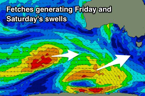
Into Friday a small inconsistent W/SW groundswell is due, generated by a relatively weak polar low that's formed east of Heard Island.
The fetch will be fairly north in latitude but track east-southeast and we may see 1ft to possibly 2ft sets across Clifton if we're lucky Friday.
 Winds will be nice and offshore from the NW through the morning with SE afternoon sea breezes.
Another very west swell is expected on Saturday morning, produced by a stronger but more zonal and north positioned storm firing up south-west of WA.
This looks dicey and I'm expecting smaller 1-1.5ft waves through Saturday with a dawn N/NW breeze, strengthening from the N/NE through the day with an approaching frontal system.
This approaching storm will be a tight low and looks to again track too north for us to see any major size across the region.
Into early next week though we'll see a stronger polar frontal progression firing up west of us, pushing across us Monday and likely bringing some more sizey swell but with wind. More on this Wednesday.

