Average weekend, good swells next week
Southern Tasmania Surf Forecast by Craig Brokensha (issued Friday 26th October)
Best Days: Early Sunday, Tuesday morning, early Wednesday, Thursday
Recap
Wednesday's swell dropped back rapidly into yesterday leaving clean tiny 1-1.5ft waves across Clifton, while our new swell for today from the weak low didn't eventuate with the low not forming as forecast.
Today’s Forecaster Notes are brought to you by Rip Curl
This weekend and next week (Oct 27 – Nov 2)
The weekend isn't looking too flash with tiny waves again tomorrow morning with a dawn W/NW offshore ahead of a strong S/SW change as a polar front pushes up and across the state.
This will bring an increase in S/SW windswell, building into the afternoon, peaking overnight and easing from 2ft Sunday morning. We will hopefully see a W/NW breeze early, swinging back onshore mid-morning.
Into next week we've got some fun pulses of SW and W/SW groundswell due, the first and least consistent arriving through Monday afternoon, peaking overnight and easing Tuesday.
This will be generated by a pre-frontal fetch of W/NW gales swinging in from the south-east Indian Ocean and along the polar shelf, tending more favourable from the W in our south-western swell window.
 This should produce a good pulse in size to 2-3ft later Monday, easing from a similar size on Tuesday.
Winds on Monday afternoon look onshore, with Tuesday morning the pick with a NW offshore ahead of sea breezes.
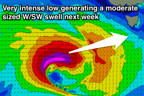
In the wake of this broad polar front we're due to see a significant low deepening in our western swell window, south of the country.
A fetch of severe-gale to storm-force W'ly winds will produce a large long-period W/SW groundswell for Wednesday that should come in at 3-4ft across Clifton when it peaks with a likely morning W/NW breeze, W/SW for the rest of the day.
The swell will ease off steadily on Thursday with better winds, but we'll have a closer look at this on Monday. Have a great weekend!

