Smaller swells, more active mid-next week
Southern Tasmania Surf Forecast by Craig Brokensha (issued Wednesday 24th October)
Best Days: Thursday, early Friday, Tuesday morning
Recap
A rapid drop in size yesterday leaving tiny 1-1.5ft waves across Clifton, while today our new spike in W/SW swell has come in nicely with clean 2-3ft sets. Sea breezes have since kicked in and we should be seeing the swell starting to ease.
Today’s Forecaster Notes are brought to you by Rip Curl
This week and weekend (Oct 25 – 28)
The strong mid-latitude low linked to today's swell has already moved off to the east and with this we'll see the swell dropping from a smaller 2ft tomorrow morning with a N/NW tending W/NW breeze.
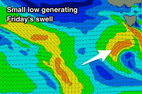
A small spike in weak new SW swell is now due on Friday, generated by a small low that's due to form west-southwest of us tomorrow morning, passing under the state tomorrow evening while generating a burst of strong SW winds.
 A small kick to 1-2ft is expected on Friday with general W/SW winds, possibly W/NW for a period in the early morning.
We're then looking at tiny start to the weekend, while a polar front pushing up and over us Saturday afternoon will bring a small increase in windswell on Sunday to a junky 2ft but with onshore winds.
Longer term a pre-frontal fetch of polar gale to severe-gale W/NW winds is due to move in from the south-east Indian Ocean and to a position south-west of us, with a possible stronger storm developing immediately south-west Tuesday.
This will generate a solid swell mid-late next week, but more on this Friday.

