Swell swinging more south as winds improve
Southern Tasmania Surf Forecast by Craig Brokensha (issued Monday 24th September)
Best Days: Wednesday, Thursday morning, Saturday, Sunday onwards
Recap
A rapid drop in size Saturday following on from Friday's strong pulse of swell with clean leftover 2ft waves.
A new W/SW swell was seen to build through Sunday but with generally average conditions, remaining less than ideal this morning.
Today’s Forecaster Notes are brought to you by Rip Curl
This week and weekend (Sep 25 - 30)
We'll fall in between swells tomorrow morning as our current W/SW swell eases, though still coming in around 2ft, but with a dawn W/NW'ly, quickly swinging SW through the morning.
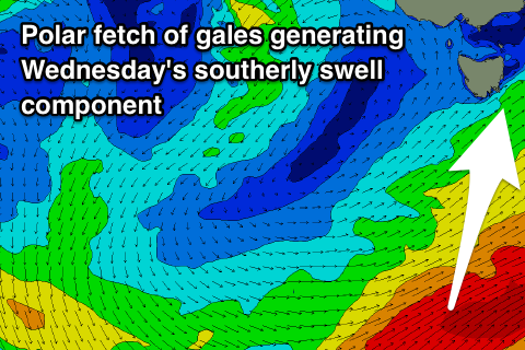
This SW'ly is linked to a strong polar frontal progression to our south clipping the state, with some new SW tending S/SW groundswell due to build tomorrow afternoon and ease Wednesday.
These swells have been generated by a strong polar frontal progression swinging in from the south-east Indian Ocean with a fetch of W/NW tending W'ly gales generating tomorrow afternoon's SW groundswell, while the S/SW swell energy is currently being generated by weaker fetch of W/SW tending SW gales in our southern swell window.
 Clifton should build to the 3ft range tomorrow afternoon but with onshore SW winds, holding a similar size Wednesday with the S/SW energy and with a light NW tending variable breeze ahead of SE sea breezes.
The swell should then ease back from 2ft on Thursday with straighter N'ly offshore winds, NW into the afternoon.
We'll see the the surf bottoming out through the end of the week, while a small and weak new W/SW swell is due Saturday from a weak polar front moving in from the west mid-late week.
We're only due to see small sets to 2ft Saturday with a W/NW breeze, but beyond this we've got some more significant swell on the way.
An elongated and vigorous polar frontal progression is due to fire up followed by what could be a very severe polar low. More on this Wednesday.

