Tricky long-range swells mixed with better close-range energy
Southern Tasmania Surf Forecast by Craig Brokensha (issued Wednesday 22nd August)
Best Days: Saturday and Sunday for the most reliable consistent swell energy
Recap
Small clean 1-2ft waves yesterday morning, but a strong pulse of swell should have been seen into the afternoon though with onshore winds. The swell dropped back rapidly into this morning, but there were still some bumpy lumpy 2ft sets for desperate surfers.
Today’s Forecaster Notes are brought to you by Rip Curl
This week and weekend (Aug 23 – 26)
We've got a low point in swell tomorrow but there should still be infrequent 1-2ft sets on the coast for keen surfers with a N/NW offshore ahead of SE sea breezes.
From Friday through Sunday we're looking at inconsistent long-range W/SW groundswells across the state, but Saturday will see a better aligned and stronger SW swell over-powering this energy.
Firstly though Friday's swell will be super inconsistent, generated in our far swell window in the southern Indian Ocean.
 Very infrequent 1-2ft sets max are due with a NW tending variable breeze.
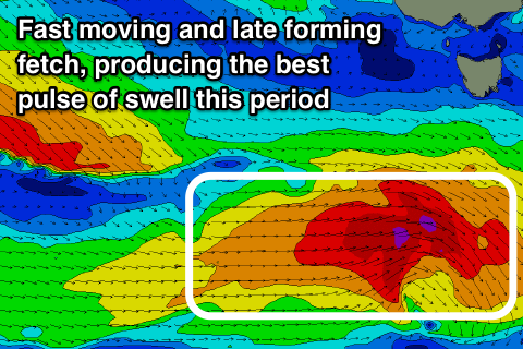
Saturday's better SW swell will be generated by the same system that will generate a slightly more consistent W/SW swell on Saturday.
Over the last two days a good pre-frontal fetch of W/NW gales were projected through our far swell window, producing the W/SW swell, but this fetch will restrengthen south-west of us tomorrow evening, generating a fetch of W'ly tending W/SW gales late in our swell window.
We should see a good pulse of new energy to 2-3ft through the morning, easing into the afternoon, with Sunday seeing small leftover amounts of background W/SW groundswell to 2ft.
Winds look great all weekend with offshore NW tending variable breezes both Saturday and Sunday.
Moving into next week, a weak polar front pushing up and across us will merge with a surface low across south-eastern Australia, deepening and stalling to our east, directing poor and strong S/SE winds into us Monday and Tuesday, generating messy levels of S/SE windswell.
We'll have a closer look at this on Friday.

