Flukey small west swells
Southern Tasmania Surf Forecast by Craig Brokensha (issued Wednesday 1st August)
Best Days: Thursday morning, late Sunday and early Monday
Recap
A sneaky pulse of W/SW swell to 1-2ft yesterday when I expected it to be tiny, while today has started slow and tiny, in line with forecasts, with a slightly better W/SW groundswell due to provide 1-2ft sets this afternoon.
Cape Sorell has strengthened in period with the arrival of this swell so we should be seeing those better 1-2ft sets on the coast but conditions are bumpy with a SW breeze. The late swing in winds to the W/NW isn't on the cards any more unfortunately, with bumpy surf continuing until dark.
Today’s Forecaster Notes are brought to you by Rip Curl
This week and weekend (Aug 2 - 5)
Want to receive an email when these Forecaster Notes are updated? Then log in here and update your preferences.
This afternoon's increase in W/SW groundswell is due to fade back through tomorrow from a tiny 1-1.5ft along with more favourable N/NW winds, strengthening from the N/NE into the afternoon.
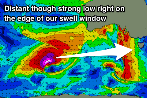
Unfortunately there's been no change to the rest of the forecast period with the coast due to become flat through Friday and the weekend, with a flukey pulse of long-period W/SW groundswell on the cards for later Sunday and Monday morning.
 We've had an upgrade in the severe-low generating this swell south-west of WA, but a slow moving fetch of storm-force W/SW winds look to be right on the edge of our western swell window.
The groundswell is expected to arrive through Sunday, tiny to flat early, with a possible late increase in energy to a very infrequent 1-2ft, easing from a similar size Monday morning.
Winds look favourable and out of the N'th on Sunday and W/NW on Monday, but we'll review this in Friday's update.
Longer term there's no real relief in sight with the storm track remaining too far north and out of our swell windows.
This is related to a strong negative Southern Annular Mode signal (below), with the polar westerlies further north than normal.


