Slow forecast period
Southern Tasmania Surf Forecast by Craig Brokensha (issued Friday 1st June)
Best Days: Tomorrow as the swell builds before the sea breeze kicks in, Sunday morning, later Wednesday and Thursday morning
Recap
Average lumpy conditions yesterday, deteriorating through the day, while this morning is much better with clean conditions and easing sets from 2ft.
Today’s Forecaster Notes are brought to you by Rip Curl
This weekend and next week (Jun 2 - 8)
Tomorrow is expected to start small to tiny, but a new long-period W/SW groundswell should build through the day, generated by an intense and tight low in our western swell window the last couple of days.
A fetch of severe-gale to storm-force W/SW winds were seen, but not ideally in our swell window.
 Still we should see building surf to 1-2ft through tomorrow with a light morning W/NW breeze, giving into SE sea breezes as the swell peaks.
Similar winds are due on Sunday as the swell eases from 1-2ft.
Unfortunately for the rest of the forecast period there's nothing significant at all on the cards besides tiny levels of W/SW swell.
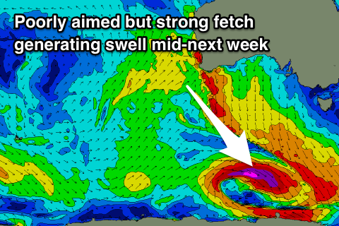
A vigorous though poor tracking and poorly aimed low will develop south of WA and project south-east through our south-western swell window, with a slither of severe-gale to storm-force winds produced in our swell window.
This may generate 2ft waves later Wednesday and Thursday morning under a N'ly breeze, but we'll review this Monday. Otherwise check out the East Coast forecast.
Have a great weekend!

