Small to tiny west swells for the period
Southern Tasmania Surf Forecast by Craig Brokensha (issued Wednesday 30th May)
Best Days: Friday morning, Saturday afternoon, Sunday morning
Recap
A small inconsistent W/SW groundswell to 1-2ft yesterday, back to a tiny 1-1.5ft this morning with a change pushing across us being too short-lived as expected.
Today’s Forecaster Notes are brought to you by Rip Curl
This week and weekend (May 31 – Jun 3)
Tomorrow morning will likely be tiny again, with a small front that was expected to kick up some S/SW swell through the afternoon now being much weaker.
We're now only due to see some small 1-2ft of W/SW groundswell from the earlier stages of the front the past couple of days, and with morning NW winds, tending SW as the swell fills in through the afternoon.
Friday looks clean most of the day with a NW tending variable breeze as the W/SW swell eases from 1-2ft.
 The flukey S/SE swell for the weekend doesn't look too favourable with the weak polar low aiming the S/SE fetch more towards WA, as well as only being short-lived.
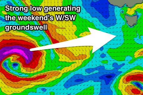
Instead though a long-period W/SW groundswell has been upgraded a little.
Currently a strong low is forming south-west of WA and will dip south while generating a fetch of severe-gale to storm-force W'ly winds in our western swell window tomorrow.
A good W/SW groundswell should build through Saturday and reach 2ft into the afternoon along with NW tending light SE winds, easing from 1-2ft Sunday morning with similar NW tending variable winds.
Longer term there's nothing major on the cards besides tiny W'ly swells, but the East Coast will see a bit of swell, so check the forecaster notes later this afternoon for an update.

