Strong S/SW swell for tomorrow, lots of swell next week
Southern Tasmania Surf Forecast by Craig Brokensha (issued Wednesday 7th March)
Best Days: Thursday, Friday morning, every morning next week
Recap
Tiny waves yesterday and this morning, but later today we should see a strong pulse of new S/SW groundswell (discussed below).
Today’s Forecaster Notes are brought to you by Rip Curl
This week and weekend (Mar 8 - 11)
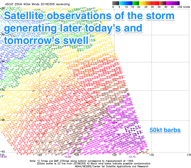
Over the last two days, a strong polar low has generated a great fetch of severe-gale W/SW winds in our southern swell window, with satellite observations recording a couple of storm-force 50kt barbs.
 A long-period S/SW groundswell is due off this low, kicking later today to 3ft across Clifton, peaking overnight and easing from a similar size tomorrow morning.
Our secondary pulse of swell for Friday isn't looking as good, with the secondary tight polar low not really forming ideally in our swell window.
Instead we'll likely just see the surf easing from 2ft across Clifton, tiny into Saturday.
Winds tomorrow and Friday morning will be great with light NW offshores ahead of afternoon SE sea breezes.
Next week onwards (Mar 12 onwards)
We've got plenty of swell due next week owing to a strong node of the Long Wave Trough strengthening across us.
This will steer a series of strong polar fronts up and into us, the first over the weekend, generating a moderate sized SW swell for Monday afternoon and Tuesday morning to 3-4ft.
Secondary frontal activity looks a little more west in orientation, with less size expected. Winds each morning look favourable and from the W/NW, but more on this Friday.

