Fun swell mid-week, tiny into the weekend
Southern Tasmania Surf Forecast by Craig Brokensha (issued Monday 31st July)
Best Days: Later Wednesday, Thursday, Friday, Monday
Recap
Tiny surf Saturday ahead of a new increase in W/SW swell Sunday which came in at 1-2ft across Clifton. This morning the swell was continuing at a good 2ft with offshore winds ahead of a shallow change.
This week and weekend (Aug 1 - 6)
Today's swell is due to fade back into tomorrow, leaving tiny waves across Clifton, fading from 1ft. Conditions should be clean with a variable breeze ahead of SE sea breezes.
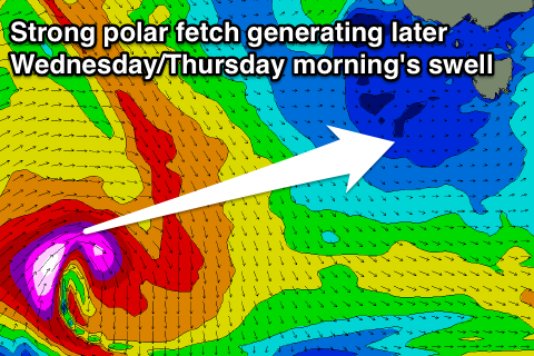
Wednesday morning will remain tiny to flat, but into the afternoon a good new W/SW groundswell is due.
 This is being generated this morning by a polar fetch of severe-gale to storm-force W'ly winds, south of WA.
We should see 2ft sets mid-late afternoon Wednesday but with E/NE winds. This will favour some spots over others. A secondary similar sized pulse for Thursday morning should keep 2ft waves hitting Clifton with N/NW tending fresh N/NE winds.
The swell isn't expected to drop below 1-1.5ft into Friday and Saturday morning, as pre-frontal W/NW gales moving through our swell window south-west of WA generate reinforcing W/SW swell pulses.
Winds look to maintain from the N/NE Friday before swinging strong W'ly Saturday as a vigorous mid-latitude low moves across us.
This isn't due to generate any major swell, with it being too west in nature, but a good new W/SW groundswell is expected Monday morning.
A strong polar low forming in the Heard Island region will project east-northeast just on the edge of our swell window through the end of the week and weekend.
The swell off this system may be seen late Sunday but a peak is expected Monday morning to 2-3ft across Clifton.
Beyond this we may see a significant S/SW swell mid-late week, but more on this Wednesday.

