Pumping Thursday, with a large swell for Saturday
Southern Tasmania Surf Forecast by Craig Brokensha (issued Wednesday 21st June)
Best Days:
Recap
Fun clean 2ft sets yesterday morning with a reinforcing W/SW swell, while today some new energy has filled in, building from 2ft this morning, further into the afternoon but with average winds.
This week and weekend (Jun 22 – 25)
Today's swell was generated by a strengthening polar front projecting towards us yesterday, with it passing under us today. The direction was W/SW today but we should see a swing to the SW tomorrow from the backside of the front, keeping 3ft sets hitting Clifton during the morning, easing into the afternoon.
Conditions will be great all day with a N/NW tending NW breeze, while Friday will be clean early with an early N/NW offshore but the swell will be tiny. An onshore change will be seen through the day, related to a very strong cold-outbreak and winter frontal progression through the Southern Ocean.
A node of the Long Wave Trough is currently strengthening across the Bight and will move slowly east over the coming days, continuing further towards New Zealand over the weekend.
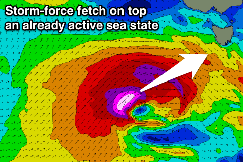
 This has already spawned a vigorous polar front south-southwest of WA, with a fetch of pre and post-frontal gales being generated (storm-force in satellite observations) through our south-western swell window. This will generate a moderate sized SW groundswell alone, but also create an active sea state for a much stronger and more significant storm to move over.
This secondary storm will form tomorrow, projecting a fetch of severe-gale to storm-force SW winds up right through our western swell window before passing under us Friday, with a weaker trailing fetch of SW gales.
What we should see is a late increase in W/SW groundswell to at least 4ft, but with those gusty W/SW winds.
A peak in SW groundswell is then due Saturday morning to a large 6ft+ across Clifton, easing steadily through the afternoon, down further from 3ft+ Sunday morning.
Winds on Saturday are looking excellent with a W/NW tending late NW breeze, while Sunday NW winds ahead of a late change.
This change will be linked to another strong polar front forming in our south-western swell window over the weekend, projecting a fetch of SW gales towards us. We should see another solid increase in size Monday to 4-5ft or so, but with poor SW winds. More on this Friday though.

