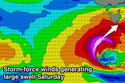
Lots of swell to come, very large Saturday
Southern Tasmania Surf Forecast by Craig Brokensha (issued Monday 19th May)
Best Days: Tuesday morning, Thursday, Friday afternoon, Saturday, Sunday
Recap
Good clean 2ft waves on Saturday, while Sunday saw a strong mix of swells filling in, coming in at 3-4ft across Clifton with the odd bigger one through the day. W'ly winds favoured protected breaks, improving a little on dark.
This morning the swell should of dropped in size, but the reports show much less size than expected, especially with Cape Sorell hanging up above 4m average wave heights. Maybe there was a long wait between sets but there should of still been 3ft waves on offer.
This week and weekend (Jun 20 – 25)
While this morning was reported at 1-1.5ft, I'm still expecting 1-2ft waves tomorrow morning as a reinforcing W/SW swell fills in. This swell was generated by a strong but unfavourably aligned fetch of W/NW gales that re currently passing under us.
The swell will ease through the day so get in during the morning for the most size. Conditions will be great all day with a N/NW tending NW breeze.
Into Wednesday we've got a good new W/SW groundswell due, produced by a strengthening polar front approaching from the west-southwest tomorrow.
 This front which is currently south of WA will produce a fetch of strong to gale-force W/SW winds nicely through our western swell window, followed by a trailing fetch of SW gales more in our south-western swell window tomorrow evening.
We should see a moderate sized W/SW swell Wednesday to the 3ft range, easing back from 3ft Thursday morning with more SW in the swell direction.
Conditions Wednesday look dicey with a dawn W/NW'ly due to swing W/SW mid-morning with the passing front, while Thursday looks great with a N/NW breeze persisting most of the day.
Now, as touched on last update, we're due to see a significant SW groundswell event later this week and into the weekend.
This will be the result of a node of the Long Wave Trough strengthening over the south-east of the country later this week, feeding and steering a vigorous polar front right up and through our western and then south-western swell windows.
An initial strong polar front will generate a fetch of pre and post-frontal W/NW to W/SW gales, creating an active sea state for a secondary much stronger and broader front to move over. This secondary front will project a fetch of severe-gale to storm-force W/SW winds initially through our western swell window, and then through our south-western swell window.
We will see a large, powerful, long-period W/SW tending SW groundswell, building Friday and peaking Saturday morning.
At this stage we're looking at building surf to 4-5ft by dark Friday with strong NW tending W/SW winds, with Saturday seeing 6ft+ sets with gusty W/NW winds, easing steadily through the day.
The models are fairly firm on this scenario but we'll have a closer look at the timing, size and local winds on Wednesday.

