Solid mix of swells for Sunday with dicey winds
Southern Tasmania Surf Forecast by Craig Brokensha (issued Friday 16th May)
Best Days: Saturday morning, Sunday in protected spots, Monday, Tuesday morning, Thursday
Recap
A strong new W/SW groundswell yesterday, keeping wave heights up around 3ft across Clifton with offshore winds, easing back from 2-3ft this morning.
This weekend and next week (Jun 17 – 23)
We should see yesterday's W/SW groundswell continue to ease over the weekend, dropping back from a clean 1-2ft tomorrow morning.
Our mix of swells into Sunday is still on track, with a small W/SW groundswell for the morning generated by a good pre-frontal fetch of W/NW gales through our swell window yesterday.
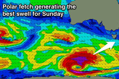
 The secondary and now likely strongest swell is being generated by a broader and stronger fetch of polar post-frontal severe-gale W'ly winds south-west of us.
This should generate a strong SW groundswell that's expected to be there at dawn, with 3-4ft sets due across Clifton.
The final swell will be from the W/SW, generated by a strengthening low moving in and under us tomorrow evening. This system has been downgraded a little and the swell from it likely to be a similar size to the SW energy.
With the mix of swells we're likely to see weird and unfavourable double-ups through Sunday and also as the swells ease Monday from the 3ft range.
Conditions are looking dicey Sunday with the passing of the front resulting in fresh W/SW winds, but another approaching front should swing winds back offshore late in the day. There's an outside chance that winds stay from the W all day as well.
Monday will be clean with persistent N/NW tending NW winds, similar Tuesday with fading 1-2ft surf.
Longer term there's some new SW swell due Thursday from a weak polar front moving in early next week, but of greater significance is a stronger polar frontal progression firing up for next weekend. We may see some larger surf off this progression but more on this Monday. Have a great weekend!

