Fun swells with good winds this period
Southern Tasmania Surf Forecast by Craig Brokensha (issued Monday 12th May)
Best Days: Tuesday afternoon, Wednesday morning, Thursday, Friday, Saturday
Recap
Only small but fun and clean 1-2ft waves on Saturday, fading back to the 1-1.5ft range Sunday morning before kicking a little again into the afternoon. This swell has held around 1-2ft this morning with generally clean conditions all day.
This week and weekend (Jun 13 – 18)
Today's small swell is due to fade back to the 1-1.5ft range tomorrow morning, but into the afternoon and Wednesday morning, a fun new SW swell is expected.
This will be generated by a strengthening frontal system currently passing under us, with a good fetch of W/SW gales being produced through our swell window.
We should see the surf kick late tomorrow to 2ft, easing from a similar size Wednesday morning.
 Winds are looking good all day tomorrow with a NW'ly, similar Wednesday.
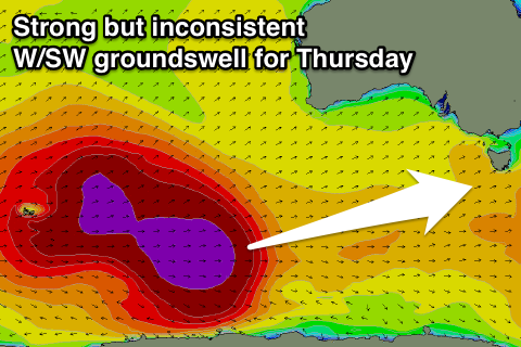
Later in the day but more so Thursday now, our strong but inconsistent long-range W/SW groundswell is due to start showing, with satellite observations over the weekend confirming a fetch of storm-force W/SW winds generated in our far swell window.
This storm is now weakening but we'll see a fetch of strong to gale-force W/SW winds continuing to be aimed through our swell window over the coming days before the system passes under us Thursday in a much weakened state.
What we should see is an inconsistent W/SW groundswell event for Thursday, coming in at 3ft on the sets, with more consistent sets into the afternoon from the incoming front, easing back from 2-3ft Friday morning.
Conditions are looking great with a light variable NW offshore due most of Thursday, similar into Friday.
Longer term a flurry of pre-frontal W/NW winds through our western swell window should generate some small W/SW swell for Saturday (1-2ft) and SW swell Sunday afternoon to a stronger 2-3ft.
The secondary W/NW fetch will be stronger and more south in latitude resulting in more size, but a strong SW change is due Sunday morning, creating poor conditions while also kicking up some SW windswell.
We'll have a closer look at this Wednesday though.

