Tiny swells with stronger surf next week
Southern Tasmania Surf Forecast by Craig Brokensha (issued Wednesday 7th May)
Best Days: Beginners Friday and Saturday, Sunday afternoon, Monday morning, Thursday next week
Recap
Onshore average waves yesterday with a mix of new swells, while today we've seen good clean conditions and easing 2ft sets.
This week and weekend (Jun 8 – 11)
The surf will continue to ease through tomorrow leaving tiny waves across Clifton, similar into Friday morning.
The mid-period W/SW swell due into Friday is now looking a little dicey with the frontal system due to be weaker than forecast Monday.
At this stage we're lucky to see much over 1-1.5ft Friday, mixed in with a long-range and inconsistent W/SW groundswell, fading Saturday from a similar size. Our models are incorrectly combining the mid-period and long-period energy Saturday morning and over-forecasting the size.
Conditions should be clean with a W/NW breeze most of Friday, persisting Saturday.
 The next swell will be generated by an unfavourably aligned but broad fetch of gale-force W/NW winds Friday and Saturday. While not well aligned, some small swell should spread out radially into the South Arm Sunday afternoon and Monday morning, coming in at 1-2ft with favourable winds.
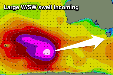
Of greater significance is a very strong storm forming around the Heard Island region this weekend. We'll see a broad fetch of severe-gale W/SW winds projected towards us through our far western swell window, with core wind speeds reaching storm to hurricane-force strength.
This storm will weaken while a secondary front spawns and moves over the top of the already active sea state.
We should see a great long-period W/SW groundswell event generated, building Wednesday afternoon, peaking Thursday to the 3ft to occasionally 4ft with what looks to be favourable winds. More on this Friday.

