Swells to peak with onshore winds
Southern Tasmania Surf Forecast by Craig Brokensha (issued Monday 24th April)
Best Days: Tuesday afternoon, possibly early Wednesday and similar Thursday, Friday morning, Sunday
Recap
Tiny waves to kick off the weekend with clean conditions, while some new swell started to build Sunday but conditions were poor with a fresh onshore wind. Conditions improved a little through the day as winds tended eased a touch.
Today was cleaner but tiny and only 1-1.5ft.
This week and weekend (Apr 25 - 30)
Tiny surf is expected tomorrow morning but into the afternoon a new SW groundswell should provide 2ft sets across Clifton with favourable winds all day. This has been generated by a strong polar frontal progression over the weekend, with it weakening to our south-west this afternoon and evening.
The tail of this progression has generated a better SW swell to 2-3ft Wednesday afternoon, but a cold front pushing across us during the day will bring a mid-morning SW change. There may be an early window of W/NW winds with clean fun 2ft sets.
 Easing 2-3ft surf is due Thursday but winds still look dicey, with only a slight chance for an early W/NW'ly.
Friday will be nice and clean but the swell back to 1-2ft max.
Into the weekend we've got two good swells due across Clifton.
The first and least consistent will be a long-period SW groundswell, generated by a vigorous low that's forming north of Heard Island today. This low will project a fetch of severe-gale to storm-force W/NW winds south-east towards and along the polar shelf, before weakening south-west of us Thursday.
The swell from this low is expected to build later Saturday and peak Sunday morning to 2-3ft across Clifton.
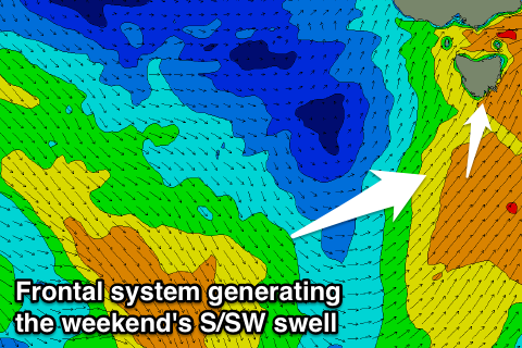
What we'll see into Friday though is a strengthening polar front of the backside of the weakened low developing south-southwest of us, projecting a fetch of strong to gale-force S/SW winds up through our southern swell window Saturday.
A moderate sized S/SW swell is due off this front, building Saturday afternoon to at least 2ft+ across Clifton but with strong SW winds.
Sunday is the pick with the S/SW swell easing from a similar size to the long-period swell (2-3ft) with NW tending W/NW winds.
Into next week there's plenty more polar frontal activity and swell on the cards but likely with onshore winds at the peak. More on this Wednesday.

