Clean easing SE swell, tiny until later Friday
Southern Tasmania Surf Forecast by Craig Brokensha (issued Monday 2nd January)
Sign up to Swellnet’s newsletter and receive the South Arm Forecaster Notes and latest news sent directly to your inbox. Upon signup you'll also enter the draw to win a surf trip to P-Pass for you and a mate. It doesn’t get much easier so click HERE to sign up now.
Best Days: Tuesday morning, Wednesday morning, Saturday morning
Recap
A continuation of tiny waves across the South Arm, lifting a touch yesterday but with average winds, and slightly more today with a weak SW windswell. A new SE groundswell should be building across the coast this afternoon but it'll be hard to distinguish with the onshore winds.
This week (Jan 3 - 6)
This afternoon's increase in SE swell should peak tomorrow morning, with satellite observations confirming a great looking fetch of strong to gale-force SE winds through our swell window the last couple of days.
Clifton should see 2ft sets tomorrow morning (larger more exposed breaks), easing into the afternoon and tiny Wednesday.
A light morning offshore wind is due tomorrow before a S'ly change moves through early afternoon.
Wednesday is then expected to see N/NE tending E/NE winds. Also in the water on Wednesday morning should be an inconsistent W/SW groundswell, generated over the weekend by a fetch of pre-frontal W/NW winds, but only 1-1.5ft sets are expected, tiny Thursday.
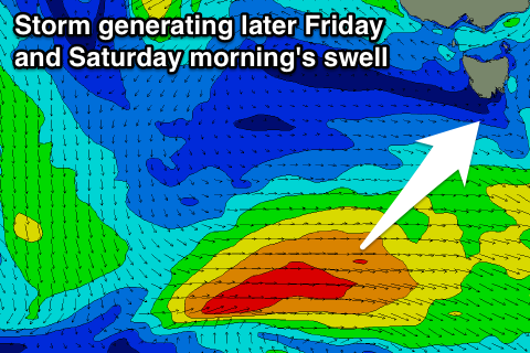
 Into the end of the week and Saturday a small W/SW and then SW swell is due across the coast.
This should be produced by a small polar low generating a pre-frontal and post-frontal NW and stronger W/SW winds through our swell window.
The pre-frontal fetch isn't ideal and will only produce 1ft sets Friday morning, but the post-frontal fetch is better and should produce better sets to 2ft+ later Friday, easing from a similar size Saturday morning.
A variable tending SE wind is due Friday, easing Saturday with a N'ly offshore through the morning.
Longer term we'll hopefully see some better frontal activity firing up next week, generating some good W/SW groundswell, but more on this Wednesday.

