Fun SW swell tomorrow, strong S'ly swell later Sunday and Monday
Southern Tasmania Surf Forecast by Craig Brokensha (issued Friday 18th November)
Sign up to Swellnet’s newsletter and receive the Southern Tasmania Forecaster Notes and latest news sent directly to your inbox. Upon signup you'll also enter the draw to win a surf trip to P-Pass for you and a mate. It doesn’t get much easier so click HERE to sign up now.
Best Days: Saturday, Sunday, Monday, Tuesday morning, Wednesday morning
Recap
Small clean 1-1.5ft waves yesterday morning, fading through the day leaving flat conditions this morning.
This weekend and next week (Nov 19 - 25)
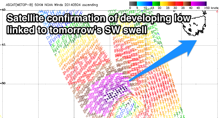
 Satellite observations have come in regarding the very intense low that fired up south-west of us, and the readings are quite impressive.
50-55kt core winds were aimed through our south-western swell window for a short period, and this has generated a strong SW groundswell pulse for tomorrow.
I'm sticking with a peak around 2-3ft through the middle of the day/early afternoon but there's a chance for the odd bigger bomb looking at the ASCAT readings.
The swell will ease back overnight, with an inconsistent W/SW groundswell keeping 2ft sets hitting Clifton.
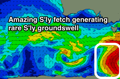
Later in the day though, the new S'ly groundswell talked about on Wednesday is due to arrive ahead of a peak overnight.
 This will be generated by a fetch fetch of polar S/SE gales wrapping around the base of the low generating tomorrow's swell, with a strong kick in size to 3-4ft due by dark Sunday, easing from a similar size Monday morning.
Winds tomorrow should hopefully hold from the W/NW all day, with NW offshores Sunday ahead of SE sea breezes.
A N/NW tending fresh N/NE breeze is then due Monday as the S'ly swell eases.
Tuesday morning is expected to be smaller, fading from 1-2ft with an early W/NW breeze.
Longer term a deepening mid-latitude low tracking south-east through our swell window early next week will aim a quick burst of W/SW gales through our western swell window Tuesday, kicking up a late increase in swell to 1-2ft, easing back from a similar size Wednesday but more from the SW. There also may be a new S'ly swell in the water from the backside of the low, but more on this Monday. Have a great weekend!

