Small W/SW swell ahead of a good S'ly swell
Southern Tasmania Surf Forecast by Craig Brokensha (issued Friday 19th August)
Best Days: Sunday keen surfers, Monday, Tuesday morning, early Wednesday
Recap
Fading tiny surf from 1-1.5ft yesterday, flat into today.
This weekend and next week (Aug 20 - 26)
There's been no real change to tomorrow's W'ly swell, with the 'bombing low' to our west generating a fetch of storm-force W/SW winds too far north and out of our swell window.
With this we'll be lucky to see anything above 1ft.
The better aligned W/SW groundswell for Sunday has unfortunately been downgraded with the low losing most of its strength before it shifts south and into our swell window this evening.
 Instead a weak fetch of W/SW winds will be aimed towards us, generating a tiny W/SW swell for Sunday, coming in at 1ft to maybe 2ft.
Conditions will be clean though with a W/NW breeze persisting most of the day.
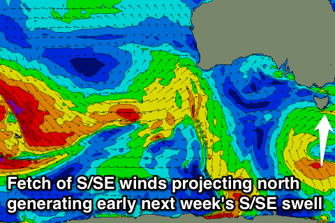
Now into early next week, Monday should see similar amounts of W/SW swell to 1ft to maybe 2ft as the low stalls under us, but a fetch of strong to possibly gale-force S/SE winds at the bottom of the low, projected slowly north just through our southern swell window should produce a good S'ly swell for later in the day and more so Tuesday and Wednesday.
This swell is expected to build later Monday to 3ft to maybe 4ft later in the day, holding 3-5ft Tuesday and then easing slowly from a similar size Wednesday morning.
Winds will be a little average with a W/SW breeze Monday and then NW tending W/SW winds Tuesday. Wednesday will become average with an early N'ly, tending more E'ly through the day.
This E'ly will be related to a broad and deepening inland low, drifting south-east and off our coast mid-late next week. This is expected to project SE gale into our East Coast, but how much swell this generates for us is still unknown. More on this Monday. Have a great weekend!

