Easing surf ahead of some new swell over the weekend
Southern Tasmania Surf Forecast by Craig Brokensha (issued Monday 15th August)
Best Days: Tuesday morning, Saturday morning, Sunday morning
Recap
The weekend started tiny but a new W/SW swell filled in Sunday with good 3ft sets under offshore winds.
The swell has held well into this morning, easing back from 2-3ft, but a new long-period pulse of W/SW groundswell should be showing now, keeping 3ft sets hitting the coast.
This week and weekend (Aug 16 - 21)
Late today's kick in long-period W/SW groundswell is expected to drop back quickly into tomorrow, but the morning should still reveal 2ft to hopefully 3ft sets, back to 1-2ft into the afternoon. All day offshore N/NW winds will keep conditions nice and clean.
Wednesday will remain tiny with a reinforcing W/SW swell from less than favourably aligned mid-latitude frontal activity not likely to get much over 1-1.5ft. Onshore S/SE winds will create poor conditions as well.
Thursday is then due to fade from 1ft, tiny to flat into Friday.
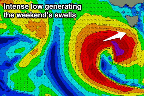
 Now into the weekend a strong and deepening low pressure system to our west is expected to drop south and more into our swell window through Friday.
With this a fetch of severe-gale to storm-force W/SW winds being generated in our western swell window.
This should produce a good W/SW groundswell for the weekend, coming in around 2-3ft Saturday, and then slowly easing from a more S/SW direction Sunday from 2ft or so. Conditions should be clean with a morning W/NW breeze both Saturday and Sunday.
Into early next week we may see the remnants of the low generating the weekend's low stall and restrengthen to our south-east, producing a good S/SE swell for Tuesday/Wednesday next week, but more on this Wednesday.

