Small westerly swells, best Thursday and Sunday
Southern Tasmania Surf Forecast by Craig Brokensha (issued Monday 8th August)
Best Days: Thursday, early Friday, Sunday
Recap
A small S/SE groundswell came in as expected Saturday with 1-1.5ft sets across Clifton with a light offshore wind. The swell faded through Sunday with not much left in the tank for a surf.
Today tiny surf continued as the swell direction shifted back to the W/SW.
This week and weekend (Aug 9 - 14)
Tiny surf is due to continue tomorrow, but our better pulse of W/SW groundswell through Thursday is still on track.
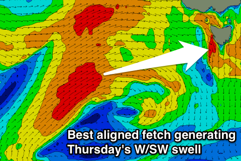
 Currently a split mid-latitude low is sitting under WA, with a fetch of severe-gale to storm-force W'ly winds being generated on the edge of our western swell window.
This low is then expected to push slowly east over the coming days, with a better aligned fetch of W/SW gales being produced.
Two pules of W/SW groundswell are expected off this system, an initial long-period increase Wednesday afternoon but likely not above 1ft+ due to where it was generated.
The secondary better mid-period pulse should build Thursday and reach 2ft across Clifton before then easing from 1-1.5ft Friday morning.
Wednesday and Thursday should see all day offshores, the former from the NW, and then the later W/NW. Friday will then see N/NW winds.
Saturday morning is expected to start tiny with a new acute W'ly swell for the afternoon probably not getting above 1ft.
Through Saturday afternoon though a strengthening polar front under us will project a fetch of W/SW gales under us, kicking up a building W/SW swell to the 2ft+ range Sunday. Winds look to hold from the W/NW-NW keeping conditions clean, with the swell easing Monday under NW winds.
Beyond this there's still nothing major with the westerly storm track remaining too far north to generate any major swell for us.

