Tiny onshore tomorrow, nothing until late next week
Southern Tasmania Surf Forecast by Craig Brokensha (issued Wednesday 3rd August)
Best Days: No good days, check the East Coast notes
Recap
The swell picked up a touch from the W/SW yesterday with 1-2ft sets but conditions were average with a light W/SW breeze, tending more onshore through the
Today the surf was tiny and back to 1-1.5ft with onshore winds.
This week and weekend (Aug 4 - 7)
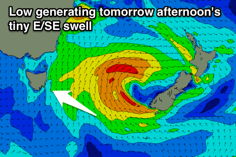
 Today's increase in SW windswell with the passing of a front yesterday will ease overnight leaving tiny waves tomorrow with lingering S/SE winds. Exposed spots to the SE may see a small E/SE swell tomorrow afternoon from a fetch of E/SE gales off New Zealand's South Island, but don't expect much above 1-2ft, fading Friday. Clifton will be tiny.
Our small pulse of SE swell for the weekend unfortunately doesn't look as favourable with the polar front generating it, pushing up to far east and close to New Zealand to generate any real size.
We may see 1ft sets Saturday, fading Sunday along with offshore winds.
Unfortunately the longer term outlook remains poor as discussed last update with the storm track sitting too far north, while also generating most of its energy in our far swell window west of WA.
This doesn't look to change until later next week, but more on this Friday.


Comments
Hey I'm confused on why other automated forecasts are producing such wildly different numbers. Magicseaweed is calling 4-7ft at Cloudy Bay, and Swellnet Forecast had 2-3ft ... how big do you think it'll be ? Why is there such a big difference ?
Thanks
MSW forecasts face feet so 4-7ft would be about 2-3ft.