Fun swell for the weekend, onshore winds developing Monday
Southern Tasmania Surf Forecast by Craig Brokensha (issued Friday 1st July)
Best Days: Saturday, Sunday morning, Thursday, Friday
Recap
Tiny waves yesterday, while today some new inconsistent W/SW groundswell was on the build. 1-1.5ft waves were reported this morning but the Cape Sorell wave buoy has since shown the groundswell proper arrive, with good 2ft sets now expected across the region.
This weekend and next week (Jul 2 - 8)
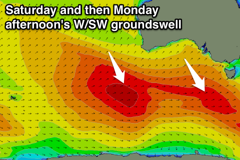
Tomorrow's W/SW groundswell is still on track with more consistent and better 2ft+ sets due across Clifton under offshore winds. This swell has been generated by a broad pre-frontal fetch of W/NW gales moving under the country the last couple of days.
NW winds should persist most of the day, possibly swinging W/NW at times through the afternoon, with N/NW tending NW winds Sunday as the surf eases from 2ft on the sets.
 Monday's long-range and inconsistent W/SW groundswell will arrive through the day and be biggest into the afternoon. Through the morning only small 1-2ft surf is expected, with a kick to the inconsistent 2ft+ range due through the afternoon.
This swell was generated in our far swell window, with the remnants of the polar low producing it currently weakening while south-west of WA.
It looks like our models are over-forecasting the size and getting the timing off a little, so don't expect 2-3ft surf Monday morning.
Winds are the issue though with a surface trough moving across us due to bring an onshore change from dawn, tending S/SE through the day.
Onshores look to persist into Tuesday as the swell eases.
Into the second half of next week we've got some fun SW groundswells from some strong polar fronts firing up late in our swell window. Size wise we're probably looking at 3ft sets, but more on this Monday. Have a great weekend!

