Small fun swells this week
Southern Tasmania Surf Forecast by Craig Brokensha (issued Monday 27th June)
Best Days: Tuesday, Wednesday, Friday, Saturday, Sunday
Recap
Plenty of swell to 2ft Saturday but with bumpy conditions under an early W'ly, while Sunday was cleaner but tiny and fading from 1-1.5ft.
Today started off tiny but a new inconsistent W/SW groundswell should of kicked this afternoon with infrequent 2-3ft sets expected.
This week (Jun 28- Jul 1)
This afternoon's expected increase in swell is due to ease back through tomorrow morning to an inconsistent 2ft, but our new W/SW groundswell due into the afternoon has been pegged back a touch to Wednesday morning.
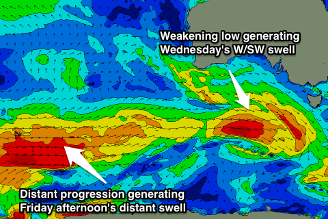
 The swell, generated by a tight and intense mid-latitude low is now weakening while approaching us, and a fun 2ft+ of groundswell is due Wednesday morning, easing into the afternoon and further Thursday.
Conditions are looking great over the coming days with offshore NW winds tomorrow, and then NW tending variable winds Wednesday. N'ly breezes will then kick in Thursday.
Into the end of the week a very inconsistent long-range W/SW groundswell is due, generated by a polar low that's currently developed in the Heard Island region.
This swell isn't due to offer any major size with infrequent 2ft sets likely into the afternoon across Clifton.
A better more consistent and slightly bigger W/SW groundswell is on the cards for Saturday though, produced by a broad and elongated fetch of pre-frontal W/NW gales moving in under the country and us through the second half of the week.
Good 2ft+ sets are due off this system under NW winds, fading back into Sunday.
Longer term a stronger cold-outbreak is on the cards for early next week but we'll have a closer look at this Wednesday.

