Fun swells to come over the period
Southern Tasmania Surf Forecast by Craig Brokensha (issued Friday 24th June)
Best Days: Saturday morning, Monday afternoon, Tuesday, Wednesday
Recap
Small waves yesterday around 1-2ft, but today a a good mix of new swells has offered better 2ft+ sets under offshore winds.
This weekend (Jun 25 – 26)
Fun 2ft waves are due to persist across the South Arm most of tomorrow as a mix of reinforcing W/SW swells fill in. The best swell was generated the last few days by a broad fetch of strong W/SW winds moving in through the Southern Ocean.
Come Sunday there isn't due to be much size left with fading 1-1.5ft sets. The odds of a morning W/NW'ly have increased for tomorrow, but a shift to the W/SW is due later morning/midday. Sunday will then see fresh NW winds persisting all day.
Next week onwards (Jun 27 onwards)
Monday's strong but inconsistent W/SW groundswell is well on track, with satellite observations picking up a great fetch of 50kt winds in our far swell window yesterday. The low has continued to produce similar strength winds while projecting north-east towards WA, just on the edge of our western swell window.
 The low is forecast to weaken while dipping back to the east-southeast over the weekend, with the swell arriving through Monday morning and peaking into the afternoon.
Small 1ft to maybe 2ft waves are due early, before kicking to a good 2-3ft after lunch. Winds are looking good as well with NW offshore expected most of the day.
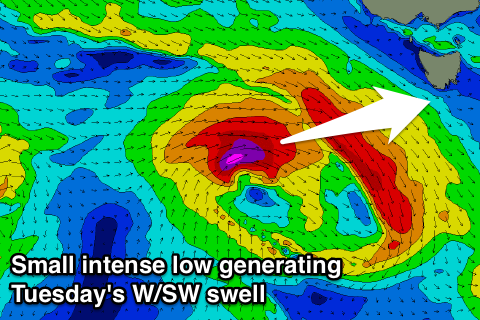
Our secondary pulse of W/SW swell for Tuesday afternoon is also on track with a small but intense mid-latitude low due to project a right fetch of severe-gale to storm-force W/SW winds through our swell window.
Clifton should kick back to 2-3ft, easing off from Wednesday.
Winds look to remain good and offshore, creating great conditions.
Longer term there's plenty more swell due into next weekend, but more on this Monday. Have a great weekend!

