Workable swells over the coming period
Southern Tasmania Surf Forecast by Craig Brokensha (issued Wednesday 22nd June)
Best Days: Friday, Saturday afternoon, Monday afternoon, Tuesday
Recap
Average onshore waves yesterday with a mix of SW and SE swells while today the mix of swells were on the ease but with better W/NW winds.
This week and weekend (Jun 23 – 26)
Today's mix of swells are due to fade overnight leaving tiny surf into tomorrow morning.
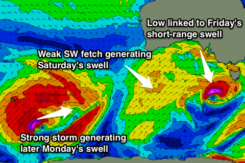
Very late in the day we may see a mix of long-range W/SW groundswell and short-range W/SW swell but Friday will be a much better chance for this.
The groundswell was generated over the weekend by an intense polar low firing up east of Heard Island, and we should see infrequent but good 2ft+ sets Friday morning from this source.
The short-range energy will be produced by a tight, intense but east-southeast tracking mid-latitude low moving in and under us from the west tomorrow. A fetch of severe-gale to storm-force W'ly tending W/NW winds will be generated, and the swell off this low doesn't look to be greater than the long-range energy, but it will fill the gaps between sets.
Offshore NW winds are due Friday morning, with a W/SW change through the day.
 Friday's mix of swells will fade into Saturday, but a reinforcing W/SW swell is due from a persistent but relatively weak fetch of strong SW winds moving through our swell window today and tomorrow.
Fun 2ft sets are expected across Clifton through the morning, easing into the afternoon and further Sunday. Winds are dicey as well now with a W/SW'ly through the morning, tending more W/NW into the afternoon as the swell eases. Sunday will then see NW winds all day.
Our inconsistent W/SW groundswell for Monday is still on track but the timing has been pushed back a touch to the mid-late afternoon.
Currently a vigorous polar low is forming in the Heard Island region, and we'll see this low project a slow moving fetch of severe-gale to storm-force SW winds in a captured fetch motion towards Western Australia. The low will then push through the Bight while weakening, continuing on and into us on Monday through our western swell window.
While not greatly aligned we should still see sets reaching 2-3ft as it kicks late Monday, easing from 2ft Tuesday. Another better aligned W/SW swell is likely into Tuesday afternoon from another vigorous front moving through our swell window, but more on this Friday.

