Small swells with a stronger W/SW groundswell Monday
Southern Tasmania Surf Forecast by Craig Brokensha (issued Monday 20th June)
Best Days: Wednesday morning keen surfers, later Thursday, Friday, Saturday morning, Monday
Recap
Clean small 2ft waves Saturday morning ahead of a building SW swell through the afternoon as winds remained favourable until about 3pm. Sunday was great with clean easing sets from 3ft with an offshore tending variable wind.
Smaller 2ft+ waves were left across Clifton into this morning, remaining clean all day again.
This week (Jun 21 – 24)
A small mix of SW and SE swells are due tomorrow but with poor winds. The SE swell will be generated by an intense Tasman Low drifting south this evening off our East Coast, aiming a fetch of SE gales through our swell window all of tomorrow. Clifton should build to 2ft through the day tomorrow with larger waves at more exposed breaks, easing back from 1-2ft Wednesday morning. The SW swell will be background energy and to a similar 1-2ft.
Conditions tomorrow will be poor with a gusty S/SW tending W/SW breeze, and then NW tending gusty W'ly winds Wednesday.
This gusty W'ly wind will be related to a strong frontal system pushing across us, but no major swell is due off this.
 A stronger tight and very intense mid-latitude low is due to push across us Thursday with a fetch of severe-gale to storm-force W/NW winds generated right under us.
This looks to be the limiting factor regarding swell production from this low with no major size above 1-1.5ft likely across Clifton.
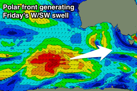
A better long-range W/SW groundswell is due to fill in later in the day and peak Friday morning though, generated by a strong polar low that's currently east of Heard Island. This low formed over the weekend and generated a fetch of severe-gale W'ly winds through our swell window, but it's currently weakening while projecting north-east towards the Bight.
The swell should kick to 1-2ft later Thursday and peak around an inconsistent 2ft+ Friday morning under offshore N/NW winds, giving into a SW change.
This weekend onwards (Jun 25 onwards)
Some small reinforcing W/SW swell is due Saturday morning but only to 1-2ft and easing through the day.
Of greater importance is a strong long-period but inconsistent W/SW groundswell due Monday week.
This will be generated by a vigorous polar low firing up around Heard Island Wednesday evening, projecting a slow moving fetch of severe-gale to possibly storm-force W/SW winds through our western swell window.
The swell is due to arrive through Monday and reach a very inconsistent 3ft across Clifton, but winds may swing onshore through the day from the SE. We'll have a closer look at this Wednesday though.

