Good swell over the weekend, slower next week
Southern Tasmania Surf Forecast by Craig Brokensha (issued Friday 17th June)
Best Days:
Recap
Solid pumping waves across the region yesterday with clean 3-5ft sets and some crazy action further afield, shot below by Dave Otto. The large swell period caused a few issues at some places and favoured others.
This morning the swell was easing back from 2-3ft with a morning offshore ahead of a shallow S/SW change.
This weekend and next week (Jun 18 – 24)
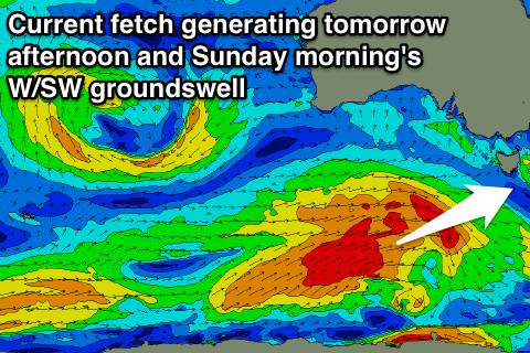
The swell over the weekend is looking a little stronger now. This is due to the second of back to back frontal systems being a bit stronger and broader than forecast Wednesday.
 A fetch of W/SW gales are producing a good W/SW groundswell for tomorrow afternoon and early Sunday, with Clifton due to kick from 2ft through the morning to 3ft. A drop from the 3ft range is also due Sunday morning.
Winds will be offshore from the NW tomorrow morning ahead of a late morning SW change, and then N/NW winds all day Sunday.
Small levels of background energy should keep 1-2ft sets hitting Clifton for most of the week with morning offshores.
Into Thursday afternoon and Friday some better long-period W/SW groundswell is due from a strong but distant polar low firing up in our swell window tomorrow. A fetch of gale to severe-gale W'ly winds will develop east of Heard Island and push towards us while weakening. This should produce good but inconsistent and better 2-3ft sets.
Thursday afternoon and Friday.
Of greater significance is a stronger and more prolonged cold outbreak across the state into next weekend with some solid S/SW swell on the cards, but we'll have another look at this Monday. Have a great weekend!

