Great Tuesday, plenty of swell to end the week
Southern Tasmania Surf Forecast by Craig Brokensha (issued Monday 26th October)
Best Days: Every day over the coming period besides Thursday
Recap
A bit more size than expected on Saturday across Clifton with a reinforcing swell producing good 2-3ft sets under light offshores. A better S/SW groundswell due Sunday offered more consistent 3ft sets with light offshores again before onshore S'ly winds kicked in.
Today a fresh to strong onshore change has created poor conditions with a mix of easing groundswell and new windswell to 2-3ft. The swell should of kicked further into this afternoon but not to any considerable size.
This week (Oct 27 – 30)
Our strong pulse of S/SW groundswell due tomorrow across Clifton is still on track with solid 3-4ft+ waves due across the coast as winds tend variable and light offshore from the N/NW ahead of sea breezes. Get in through the morning for the most size though as the swell will fade back to 2-3ft through the afternoon.
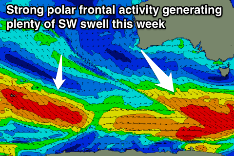
For the rest of the week and weekend there's plenty of waves on the cards as front after front pushes along the polar shelf through our swell window.
 Each system won't be ideally aimed, with the direction of the fetch being more W/NW than W/SW but the width and elongated nature of each system should help produce plenty of size.
Wednesday morning is likely to be a low point with 2ft sets still expected across Clifton, ahead of the first pulse of decent SW groundswell arriving later in the day and peaking through Thursday to 2-3ft.
Winds are looking a little dicey though with morning W/NW winds Wednesday giving into an onshore afternoon change and then S/SE winds into Thursday.
Friday should be cleaner as winds tend variable again but the swell easing back from 2ft or so.
This weekend onwards (Oct 31 onwards)
Into the weekend we'll see our closer-range swell window dry up a little, but some long-range and less consistent energy is due into Saturday and Sunday.
This will be from similar but more distant polar frontal activity between Heard Island and West Oz, producing less consistent 2ft sets through Saturday and Sunday morning before fading.
Winds will strengthen from the N/NE on Saturday which is less than ideal, with N/NW offshores Sunday ahead of a SW change.
Longer term there's hints of a solid S/SW groundswell for early next week but we'll have a closer look at this on Wednesday.

