S/SE swell with improving winds
Southern Tasmania Surf Forecast by Craig Brokensha (issued Monday 6th July)
Best Days: Wednesday, Thursday morning, Saturday
Recap
Saturday morning saw us fall in between swells with a clean 2-3ft wave across Clifton under varying W/NW winds. A late and strong increase in new SW swell was seen, with Sunday coming in at 3-4ft, a touch under the expected 3-5ft. Winds were great and light offshore before tending variable (light onshore into the afternoon).
Today the swell was back to a smaller 2-3ft with onshore winds in the wake of a funky trough pushing east across us.
 This week (Jul 7 – 10)
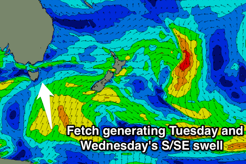
Our S/SE swell due into tomorrow and Wednesday has been upgraded a touch in size. The polar fetch of strong S/SE winds generating the swell is projecting favourably northwards through today, before moving out of our swell window Tuesday.
This should produce a good pulse of S/SE swell, building tomorrow to 3ft across Clifton into the afternoon, and then easing from 3ft Wednesday morning, further down from 2ft Thursday.
Winds will remain poor tomorrow and onshore from the S/SE, tending lighter E'ly into the afternoon.
Wednesday will be much cleaner with N/NW tending N'ly winds. As the swell fades, N/NW winds will keep it clean.
This weekend onwards (Jul 11 onwards)
A small pulse of W/SW groundswell is due Saturday afternoon from a pre-frontal fetch of W/NW gales pushing in from the west over the coming days.
This should offer infrequent 2ft sets across Clifton from mid-late morning but early W/NW winds are due to swing onshore at some stage through the day.
Into Sunday a new small W/SW swell be the seen, but some better and larger SW and S/SW groundswell are due the following week, more on this Wednesday.

