Average week, better into the weekend
Southern Tasmania Surf Forecast by Craig Brokensha (issued Monday 12th January)
Best Days: Tuesday at exposed breaks, early Friday for small easing waves, early Sunday in protected spots, Monday
Recap
The weekend didn't really deliver with a small spike in SW swell due Saturday with dicey winds, failing to really show, with tiny bumpy waves breaking across the region. Sunday was cleaner but still tiny and only for beginners.
Today another pulse of SW swell due across Clifton came in as expected with good clean 2ft waves across the region under N'ly offshores before gusty SE sea breezes kicked in.
This week (Jan 13 -16)
Today's lift in SW groundswell should hold into tomorrow morning to 1-2ft across Clifton before fading off through the day and further Wednesday. Winds will be a bit of a problem and fresh from the N/NE early before strengthening from the NE. So locations away from the South Arm are probably worth a look.
Wednesday will be poor as a deepening surface trough directly off our East Coast directs a strengthening SE wind into the south of the state, creating terrible conditions while also kicking up a junky S/SE windswell to 2-3ft late in the day.
The low is expected to strengthen further overnight, aiming stronger gale-force S/SW winds into us before slowly moving off to the east Thursday afternoon.
This should see larger levels of S'ly windswell to 3ft+ develop across Clifton into Thursday morning but with strong SW winds.
A drop in size should be seen into the afternoon and further Friday from 1-2ft as winds tip back to the N/NW.
 This weekend onwards (Jan 17 onwards)
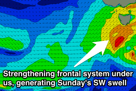
We're looking at a much better outlook into the weekend and beyond as a strengthening polar front forms south-west of WA during the middle of the week and projects towards us under the influence of a strengthening node (peak) of the Long Wave Trough.
An initial increase in W/SW swell is due Saturday morning, but we should see bigger levels of SW swell developing through Saturday afternoon and Sunday as the frontal system stalls under us and strengthens.
A fetch of SW gales are due to be aimed into the South Arm, kicking up 3-4ft of swell for Sunday. Winds look to be a bit of an issue and fresh to strong from the SW, but an early W'ly might be on the cards for Clifton.
Into Monday the swell is likely to tend more S/SW while easing under more favourable winds, but we'll review this again on Wednesday.


Comments
Craig, what the story with this "tertiary" se swell? Are we expecting nothing from this low down south of the Huon valley?
When are you talking about SD? Should see S/SE windswell developing today and then easing tomorrow with some small SE swell from the bottom flank of the low into the afternoon, fading Friday.
Tomorrow/friday..... There's a legendary left down here only open to sse thru ese swells... was hoping for something of substance off this low currently blowing its ring out...
Think I know the spot, don't think there'll be enough size, fetch producing the swell is very thin, small and short-lived.
And low is moving away from the SE fetch, hence having to work on an inactive sea state as it does.
Yep, and that.
Caught this spot 4 times in 3 years.......... :/
If it's the one I'm thinking of it would be very fickle indeed. When surfing looks as if the swell is coming from the E/NE, which is impossible for where it is located. That old sooty stuff and all?
Hmmmm. I don't think it is the one.... You would 've driven past it on your way to "walk out to the lion"........This is it -
Just around the corner to the right from here - breaks into the protected bay in the background... The outside of this "right point" is also the left point, if ya get my drift...
Ah very nice, yeah not the one I'm thinking of.