Fun swell Wednesday for exposed spots
Southern Tasmania Surf Forecast by Craig Brokensha (issued Monday 5th January)
Best Days: Wednesday at exposed breaks, Thursday morning for beginners
Recap
Not much on offer over the weekend with a hot offshore wind and tiny swell Saturday, becoming tinier and more wind affected Sunday.
Today the swell is still tiny and around 1ft, with nothing too major for the coming week.
This week and weekend (Jan 6 -11)
The only real notable swell due across the state this coming period is due Wednesday and then Saturday.
Wednesday's swell has been and is still being generated by some strong polar frontal activity to the south-west of WA over the weekend, pushing closer to us today.
Size wise we're not looking at much above 2ft on the sets through Wednesday as it peaks through the middle of the day/afternoon. The morning may be a little undersized, so don't aim for the dawny.
 Winds look OK for protected spots with a fresh and strengthening N/NE wind. With this in mind it may be worth a look further afield for a wave.
The surf should drop into Thursday with morning offshores, and then a weak front pushing up and into us during Wednesday/Thursday before weakening Friday, should produce a small kick in size. Clifton should kick to 2ft later in the day Friday and then ease from 2ft or so Saturday.
Winds aren't looking flash though with a trough moving in from the west bringing strengthen S'ly winds shortly after dawn.
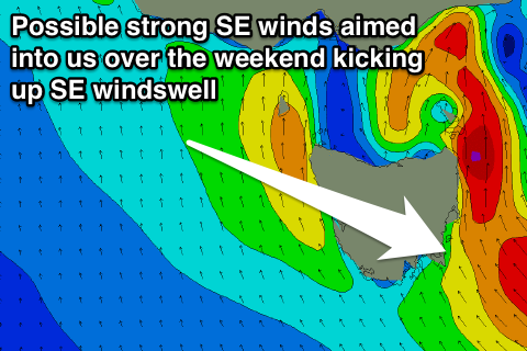
Another trough may deepen off our east coast during the weekend and with this we could see strong SE winds aimed through our swell window, kicking up some SE windswell into next week, but more on this Wednesday.

