Good swell filling in Sunday, smaller pulses next week
Southern Tasmania Surf Forecast by Craig Brokensha (issued Friday 26th December)
Best Days: Sunday morning, Monday, Wednesday morning
Recap
Small levels of W/SW swell have provided fun waves across the South Arm the last couple of days, but the window for clean conditions this morning was shut before dawn, with the SW'ly already up and blowing at first light.
 This weekend (Dec 25 - 28)
Today's swell is expected to drop back to a tiny 1ft+ tomorrow, but there's been no real change to Sunday's swell. We should see Clifton building from 2ft during the morning to 2-3ft through the afternoon although morning offshore N/NW winds will give way to SE sea breezes mid-afternoon.
Monday onwards (Dec 29 onwards)
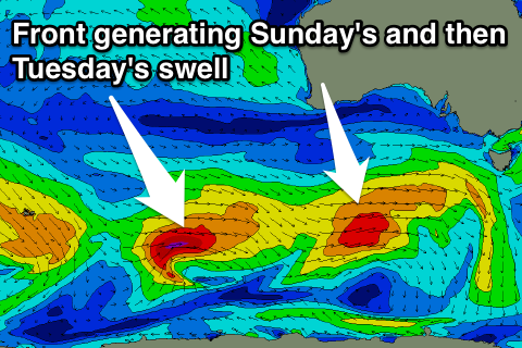
Sunday's swell is due to ease through Monday from 2ft under offshore N'ly tending N/NE and then variable winds, but a secondary W/SW swell is due into Tuesday. This will be generated by a polar low that's currently fired up east of Heard Island on the tail of the system generating Sunday's swell.
A fetch of gale to severe-gale W/SW winds will be generated in our far swell window, producing an inconsistent but good 2ft of swell for Tuesday, easing back through Wednesday.
Winds unfortunately look to go onshore from the W/SW around dawn on Tuesday, while Wednesday should see NW tending W/SW breezes.
Into the end of the week we should see another fun pulse of W/SW swell as a strengthening polar front pushes up towards and then under us from Tuesday through Thursday.
We're probably looking at 2ft or so of swell again, but we'll have another look at this on Monday. Have a great weekend!

