Poor tomorrow, fun Friday morning, possibly more interesting next week
Southern Tasmania Forecast (issued Wednesday 22nd October)
Best Days: Friday morning, Sunday morning exposed spots
Recap
Clifton was a good fun clean 2ft yesterday under morning offshores before winds went to the east into the afternoon.
Today winds started a little N'th but swung NW through the morning with a smaller 1-2ft of swell but S/SE sea breezes have since kicked in. A late change is due and this will linger into tomorrow creating poor conditions.
This week and weekend (Oct 23 - 26)
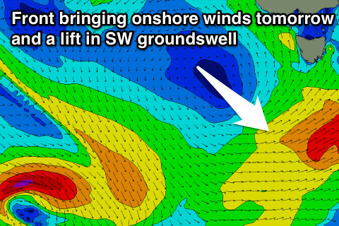
 Tomorrow's increase in S/SE windswell looks to be a non-event now with the change moving through overnight not lingering like it was expected.
A better mix of long-range W/SW and close-range SW swell is due though from a quick burst of SW gales to our south-west today (right).
This should kick up 2ft waves tomorrow afternoon before dropping away from 2ft Friday morning. Conditions will be poor tomorrow with a fresh S'ly tending lighter SE winds.
Friday should see fresh and gusty N/NE winds, which aren't ideal but workable for other spots away from Clifton.
There's nothing major on the cards for the weekend with another onshore change through Friday night leaving lingering onshore S/SW winds into Saturday. A small pulse of SW swell to 1ft to maybe 2ft may be seen from this change Sunday morning but winds will be average with strengthening from the NE.
Next Monday onwards (Oct 27 onwards)
We've got some interesting developments looking into next week with a couple of favourable mid-latitude and polar frontal systems expected to generated some fun W/SW swell from later Tuesday onwards.
But... latest models updates have one of these systems deepening significantly while approaching us early next week possibly generating a large and powerful W/SW groundswell.
The models are not in agreement regarding this though, so we'll keep a close eye on the updates and provide a more in depth look on Friday.

