Solid swells all week, cleanest Friday
Southern Tasmania Forecast (issued Monday 4th Aug)
Best Days: Tuesday, Wednesday, Thursday, Friday
Recap
A good pulse of W/SW groundswell overnight Friday held into Saturday to 3ft across Clifton with offshore NW winds. A drop in size was seen through the day though with smaller but fun 2ft waves leftover into Sunday.
This morning the swell held in at 2ft but a late kick in W/SW groundswell should have been seen, generated by a vigorous polar front pushing in from the west and under us today. More on this below.
This week (Aug 4 - 8)
This afternoon's kick in W/SW groundswell is related to a vigorous but zonal polar front passing under us today.
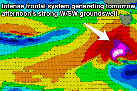
 Behind this though a much stronger system is forecast to produce a quick burst of severe-gale to storm-force W/SW winds through our swell window this evening.
This should generate a strong W/SW groundswell pulse for tomorrow, building to 4-5ft across Clifton through the day. At dawn the swell may be a little undersized, but come midday it should be alive and kicking.
Winds should be offshore from the W/NW early but with the front passing by we may see a temporary swing to the W/SW before hooking back to the W/NW during the afternoon.
A rapid drop in size is due into Wednesday due to the quick movement of the front off to the east with smaller 3ft surf due through the morning as winds hold strong from the W/NW.
Another pulse of acute W'ly swell is due late Wednesday but more so Thursday morning as a broadening and strengthening fetch of unfavourable W/NW winds passes under us Wednesday.
This should provide 3-4ft sets across Clifton Thursday morning before easing slightly into the afternoon. Winds don't look as good, with a fresh SW'ly at dawn in the wake of the front, but this should swing more W'ly through the morning.
On the back of this front a good pulse of S/SW groundswell is due for Friday morning, produced by a broad fetch of severe-gale SW winds projecting up towards New Zealand from below us.
A peak is due Friday morning to 3-4ft ahead of a drop into the afternoon and winds will be excellent and from the N/NW all day.
This weekend onwards (Aug 9 onwards)
Friday's swell will drop rapidly and we're only expected to see smaller 1-2ft leftovers into Saturday.
Through Sunday though a strong and powerful SW groundswell is expected to build across the state. This will be generated by a vigorous polar front progression firing up west of Heard Island, pushing slowly east while generating winds in the severe-gale range from today through until the weekend.
A large SW groundswell will result, building Sunday and reaching 4-5ft later in the day. Monday morning should see similar size waves but unfortunately a change through Saturday night will see onshore winds both Sunday and Monday. More on this on Wednesday.

