Stormy Thursday and Friday, better Sunday and Monday
Southern Tasmania Forecast (issued Wednesday 16th Jul)
Best Days: Saturday morning, Sunday, Monday, Tuesday
Recap
A new W/SW groundswell due yesterday came in above expectations with 2-3ft sets across Clifton with offshore winds. The swell dropped away considerably into today though leaving tiny to small waves best suited to beginners.
This week and Saturday (Jul 17 – Jul 19)
There's been no real change to the swell forecast tomorrow with an inconsistent W/SW groundswell expected to build to 2ft through the day. Winds are now looking poor though as a deepening low pressure system moves across us bringing with it strengthening S/SE winds and also a building S/SE windswell. There's an outside chance of variable winds at dawn but this won't last long.
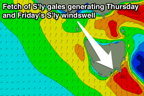
 Friday will now see more size through the morning as the fetch of S'ly winds reach the gale-force range into Friday morning, kicking up stormy 3ft waves across Clifton.
The low is forecast to push up the East Coast during the day though and with this we'll see the S'ly windswell ease as winds swing more SW.
Come Saturday only a small mix of leftover and easing 2ft waves are due under favourable W/NW winds.
This Sunday onwards (Jul 20 onwards)
A good pulse of SW groundswell is due Sunday afternoon ahead of a secondary slightly smaller pulse Tuesday. These swells will be produced by a couple of strong but small polar fronts pushing east from a position south of WA along the polar shelf and through our south-western swell window.
Sunday's increase should be to 3ft later in the day before easing back from 2-3ft Monday morning. Tuesday's increase looks to be more in the 2ft range with the odd 3ft set possible.
Winds look good Sunday with a W/NW tending variable breeze, if not light SW and then offshores into Monday and Tuesday.
Longer term there's nothing significant on the cards as the stormy track focusses itself back up towards WA and out of our swell window, but we'll look at this again Friday.

