Average end to the week, better options next week

South Australian forecast by Craig Brokensha (issued Wednesday February 12th)
Best Days: Keen surfers Mid Coast Friday and later Saturday, South Coast Monday morning, Mid Coast next Tuesday afternoon and Wednesday
Features of the Forecast (tl;dr)
- Building W windswell later tomorrow with strengthening W/NW winds
- Mod-large mid-period W swell for Fri, easing Sat and tiny Sun
- Moderate sized spike in S/SW swell Sat AM down South with a reinforcing S/SW swell for Sun, easing Mon
- Mod-fresh S/SW winds on Fri, strengthening later and remaining strong Sat before tending S/SE later (outside chance of lighter S winds on the Mid early AM)
- Mod-fresh E/SE tending S/SE winds Sun (E'ly down South AM)
- E/NE-NE tending E/SE winds Mon
- Moderate + sized, inconsistent W/SW groundswell building Tue, peaking later, easing Wed
- Strong S/SE winds Tue, SE tending S/SE winds Wed
Recap
The South Coast offered cleaner surf yesterday morning with a mix of swells to 2ft+ off Middleton while the Mid Coast came in flat.
Today, the Mid remains flat while the South Coast is cleaner and more lined up but back to 1-1.5ft.
This week and weekend (Feb 13 - 16)
Tomorrow will be a lay day across both coasts thanks to tiny surf down South and strengthening W/NW winds on the Mid Coast, kicking up building levels of windswell.
This will be thanks to a mid-latitude low moving in from the west, bringing with it an initial increase in low quality swell that should reach 2-3ft by the close of play tomorrow across the Mid Coast, tiny down South.
Into Friday, stronger levels of mid-period energy W/SW energy is due, generated by the earlier stages of the low to the south-west and south of Western Australia yesterday and today.
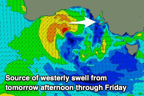
A tight fetch of strong to gale-force W/SW-SW winds should produce 3ft sets on Friday, easing through the day with Saturday backing off from a smaller 2ft.
The South Coast won’t see any size from the initial low passing under WA, but as it passes under us tomorrow afternoon and evening, a short-lived burst of gale to severe-gale SW winds should kick up a decent increase in size later Friday but more so Saturday morning to 3-4ft across Middleton.
Local winds will unfortunately be moderate to fresh out of the S/SW on Friday, with only slight chances of early light S’ly winds on the Mid Coast and early W/NW winds around Victor, with winds due to strengthen into the evening.
Saturday will then see persistent, strong S/SW winds with again, only an outside chance of lighter S winds at dawn across the Mid Coast, tending S/SE later in the day and then improving Sunday once the swell becomes tiny.
E/SE morning winds are due on the Mid Coast Sunday with E winds down South along with moderate levels of mid-period S/SW swell generated by an elongated polar front projecting up behind the low moving in tomorrow.
Middleton looks to come in around the 4ft range while the Mid Coast only looks to be 1ft or so.
Into next week, Monday morning will offer a window of E/NE-NE winds and easing S/SW swell from 3ft+ while another trough will push through into the afternoon/evening, bringing a return to strong S/SE-SE winds.
On the plus side, the Mid Coast is expected to see some fun W/SW groundswell, generated by a strong low forming north-east of the Heard Island region tomorrow evening.

The catalyst for the low will be Tropical Cyclone Vince drifting south from the Indian Ocean and being absorbed into the westerly storm track, with a great fetch of severe-gale to storm-force SW winds due to be projected through our western swell window before the low breaks down south of Western Australia this weekend.
There’ll actually be two pulses of W/SW groundswell from the low, an initial small increase Tuesday morning from a small pre-frontal fetch at the head of the low, with the better increase from the backside due into the afternoon/Wednesday morning.
The Mid Coast should come in at 2ft with the South Coast offering 3-5ft sets under those unfavourable local winds. We’ll confirm this Friday.