Mix of tricky swells and winds

South Australian Forecast by Craig Brokensha (issued Monday December 23rd)
Best Days: South Coast tomorrow morning mid-late AM, Wednesday morning exposed breaks, Saturday morning for the keen South Coast, Sunday morning both coasts, Monday morning both coasts
Features of the Forecast (tl;dr)
- Fading swell on the Mid Coast tomorrow with a new S/SW swell down South, smaller during the day
- Variable tending light E/NE-NE winds down South ahead of sea breezes, E'ly ahead of sea breezes on the Mid Coast
- Smaller Wed with gusty N/NE tending N/NW winds ahead of late sea breezes
- Strengthening N/NW tending W/NW winds ahead of a late W/SW change with a building windswell on the Mid Coast late
- New mix of W/SW swells Fri with gusty SW tending W/SW winds
- Small to moderate sized W/SW swell Sat through Mon, strongest on the South Coast Sun/Mon
- Fresh W/NW tending W/SW winds Sat, variable tending light offshore Sun AM ahead of sea breezes
- Easing surf Mon with N/NE-NE tending S/SE winds down South, E/NE tending W/NW on the Mid
Recap
The weekend was poor across the South Coast with cool, strong, onshore winds while the Mid Coast saw a fun pulse of W/SW swell into Saturday afternoon, with yesterday morning providing great 2ft sets under favourable winds.
The swell was hanging in at 1-2ft this morning but with less favourable conditions.
This week and weekend (Dec 24 - 29)
Today’s localised energy will ease back through tomorrow on the Mid Coast with weak, fading 1ft sets due under a light offshore wind. The South Coast will some new mid-period S/SW swell from today’s front clipping the state, with sets to 3ft, easing through the day but under a variable E/NE-NE breeze.
It’ll likely be lumpy at dawn but improving mid-late morning before sea breezes come in.
Christmas Day is still looking clean but smaller and to 1-2ft across Middleton, with the magnets down South performing best under a moderate to fresh N/NE tending N/NW breeze ahead of possible late sea breezes.
Into Thursday, strengthening N/NW tending W/NW winds ahead of a late W/SW change will kick up building levels of windswell across the Mid Coast to 2ft+ or so later, while the Middleton will be clean but a slow 1-2ft with some small, long-range energy preventing it from going flat.
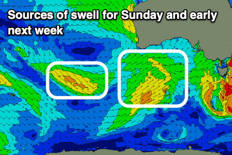
Now, this change was expected to be associated with a deepening mid-latitude low moving across us, bringing a moderate sized increase in swell for Friday and the weekend but instead the system looks weaker and mainly a fast moving front.
Instead, small to moderate sized pulses of mid-period W/SW swell are due from Friday through the weekend, with the best for the South Coast due to peak Sunday morning.
Firstly, on Friday the Mid Coast should see a mix of easing windswell and new mid-period energy in the 2ft range but fresh SW tending W/SW winds will continue to create poor conditions.
A little less size is expected Saturday as winds tip W/NW for the South Coast during the morning along with 2ft sets across Middleton, while the Mid Coast will remain poor and onshore.
Sunday’s swell should be generated late week by a healthy frontal system passing under the country and this will likely boost Middleton to 2-3ft, holding a similar size Sunday while the Mid Coast also holds the 1-2ft range.
Local winds should start to back off across the Mid Coast and tend S/SE through the morning with a W/NW breeze down South on Sunday while Monday looks better for more exposed breaks as winds tip back to the N/NE-NE down South and E/NE on the Mid.
Looking at the rest of the week and a trough looks to bring a strong S’ly change Tuesday with S/SE winds into the middle to end of the week along with what looks to be a moderate sized W/SW swell. We’ll have a closer look at this on Christmas morning.