Large W/SW groundswell for next week

South Australian Forecast by Craig Brokensha (issued Friday December 13th)
Best Days: South Coast tomorrow morning and Sunday morning, Mid Coast for the keen later Tuesday but more so Wednesday and Thursday, South Coast Thursday morning
Features of the Forecast (tl;dr)
- Easing S/SW swell over the weekend with E/NE-NE tending S/SE winds tomorrow, N/NE tending NW on Sun
- Low point in swell Mon with strengthening N/NW winds ahead of a S/SW-SW change
- Large W/SW groundswell building Tue with strong but easing SW winds, peaking Wed AM with freshening S/SE-SE winds
- Easing swell Thu with E/SE tending W/SW winds inside the gulf, E/NE tending S down South
- Smaller Fri with S winds
Recap
Early light winds and some new swell provided fun options across the South Coast yesterday with 3-4ft sets. The afternoon became stronger and larger but with a strengthening onshore wind and poor conditions. Winds are still onshore this morning but with less strength and with easing 3-4ft sets across Middleton.
The Mid started tiny yesterday before pulsing to 1-1.5ft with the peak of swell, back to a tiny 1ft this morning.
This weekend and next week (Dec 14 - 20)
Looking at the weekend ahead, we’re expecting a slow downwards trend in swell and period thanks to weak but persistent frontal activity following the strong low on Wednesday.
The Mid will be tiny while the South Coast should see Middleton easing from 2-3ft tomorrow with 1-2ft waves leftover on Sunday.
Winds tomorrow look E/NE-NE through the morning, with slightly peaky conditions ahead of sea breezes, cleaner Sunday with a N/NE offshore but that smaller, fading swell. Winds are even due to go variable NW into the afternoon but the morning will be the pick of it.
The surf will bottom out into Monday and a strengthening N/NW winds will give way to a S/SW-SW change.
This change will be associated with the remnants of a strong mid-latitude frontal system pushing up towards and then under Western Australia, weakening once pushing through the Bight. It will still bring strong SW winds on Tuesday along with a large increase in W/SW groundswell that’s due to peak Wednesday morning.
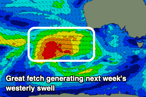
The swell will be generated by the earlier stages of this frontal progression, with a fetch of slow moving W/SW gales to the south-west of Western Australia due to project through our western swell window from today through the weekend.
The westerly angle should see the Mid Coast reach an easy 3ft on the favourable parts of the tide later Tuesday and Wednesday (not ideal with the big morning high tide).
The South Coast looks to come in around 4-5ft but less consistent thanks to the westerly angle and freshening S/SE-SE winds will favour the gulf over Victor.
The easing trend looks slow through Thursday with the Mid likely to maintain 2ft+ sets with the South Coast easing from 3-4ft under E/SE winds in the gulf and E/NE morning winds down South.
A trough will likely bring S’ly winds again Friday as the swell fades, but we’ll confirm this on Monday. Have a great weekend!