Fun swells to come but winds won't play ball
South Australian Forecast by Craig Brokensha (issued Friday December 6th)
Best Days: This afternoon Mid Coast for small runners, South Coast Monday morning, Mid Coast Monday for the keen
Features of the Forecast (tl;dr)
- Temporary low point in swell early tomorrow ahead of a moderate sized, mid-period W/SW swell arriving mid-late AM, peaking into the PM
- Freshening SW-S/SW winds from dawn tomorrow, stronger into the PM
- Easing swell Sun AM with moderate S/SW winds (S/SE early Mid Coast), freshening through the day
- Moderate sized mid-period S/SW swell Mon with E/SE tending variable winds on the Mid, E/NE tending fresh S/SE down South
- Easing swell Tue with strong S/SE winds
- Mix of building mid-period S/SW swell Wed and long-range W/SW groundswell, peaking into the PM, easing slowly Thu
- Freshening S/SE tending S/SW winds Wed, S/SW-SW on Thu
Recap
Wednesday’s good W/SW swell eased back in size yesterday but maintained 2ft on the Mid Coast with morning northerly winds tending variable into the afternoon. The South Coast was a clean 2ft to occasionally 3ft along with relatively decent conditions all day.
Today the swell is down and early onshore winds have since tended variable down South and offshore across the Mid Coast but the swell looks a bit limp. The afternoon inside the gulf should be fun as winds remain variable thanks to a weak low moving across us.

Glassy surf yesterday afternoon
This weekend and next week (Dec 7 - 13)
We’ve expecting a low point in swell early tomorrow, but from mid-late morning, a good pulse of new mid-period W/SW swell is due, generated mid-week by a healthy fetch of W/SW winds to the south of Western Australia.
This should kick the Mid Coast to 2ft into the afternoon before easing back from 1-2ft on Sunday and the South Coast should build to 3ft off Middleton, easing back to 2-3ft on Sunday morning.
Local winds tomorrow will unfortunately go onshore from around dawn, freshening from the SW-S/SW during the morning (strong into the afternoon), with an outside chance of dawn S/SE winds on the Mid Coast (don’t count on it).
Sunday will unfortunately see lingering S/SW winds across the South Coast with early S/SE winds inside the gulf but with that easing swell.

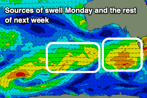
Moving into next week and a stream of healthy frontal systems moving in, under the country should generate fun levels of mid-period SW swell, strongest Monday morning ahead of reinforcing pulses mid-late week.
Monday’s swell will be generated by the first and best looking frontal system, with a great fetch of W/SW winds under us tomorrow, reaching near gale-force early Sunday in our southern swell window.
This should produce a moderate sized, mid-period S/SW swell for Monday morning to 3-4ft across Middleton, easing into the afternoon and then down from 2-3ft on Tuesday.
The Mid Coast should see 1-1.5ft waves mostly Monday with 2ft sets on the favourable parts of the tide, easing back through Tuesday.
Local winds should tip E/NE down South on Monday morning and be E/SE across the Mid Coast with variable afternoon breezes, tending gusty S/SE down South.
Tuesday unfortunately looks poor down South with a gusty S/SE breeze that will tend SE across the Mid Coast through the morning.
Into Wednesday, a new, long-range W/SW groundswell should start to build, generated by a strong, distant low that’s currently north of Heard Island.

This low is generating a fetch of severe-gale to storm-force W/SW winds and should produce a small to moderate sized, inconsistent groundswell Wednesday afternoon to 2ft on the Mid Coast with 3ft sets across Middleton, mixed in with some new mid-period swell energy.
S/SE tending S/SW winds look to spoil this new swell, with lingering S/SW-SW winds likely into Thursday.
Longer term, things slow down a little into next weekend and early next week but more on this Monday. Have a great weekend!

