Tiny swells continue for the Mid, with windows down South
South Australian Forecast by Craig Brokensha (issued Friday October 25th)
Best Days: Both coasts this morning, South Coast tomorrow, Mid Coast Monday through Wednesday for the keen, South Coast Wednesday morning
Features of the Forecast (tl;dr)
- Easing swell tomorrow with gusty N/NE tending N/NW winds
- Small-mod sized W/SW swell Sun PM/Mon with S/SE tending gusty SW winds Sun (late S/SE), S/SE tending S/SW Mon (late S/SE)
- Moderate sized SW swell building Mon, easing Tue with E/NE tending S/SE winds down South
- Moderate sized SW groundswell Wed with E/NE-NE tending S/SE winds
- Easing surf Thu/Fri with S winds
Recap
Our new W/SW swell was a little undersized yesterday morning and with average winds across the Mid Coast, but as the day progressed we saw the swell kick in with good 2ft sets under workable onshore winds into the afternoon. The South Coast saw OK winds at dawn but quickly deteriorated.
Today both coasts are much better with light, local offshore winds and 2ft of swell inside the gulf, 3ft across the South Coast.
This weekend and next week (Oct 25 - Nov 1)
The current swells across both coasts are due to ease into the weekend with fading 1-2ft sets across Middleton down South tomorrow, 1-1.5ft inside the gulf.
A gusty N/NE offshore is due to shift N/NW into the afternoon, creating favourable conditions for the exposed beaches.
Now into Sunday, the swell will reach a low point across the South Coast and a trough will bring a shallow S/SW change.
The Mid Coast should see morning S/SE-SE winds and some new mid-period W/SW swell is due to build through the day, generated by distant frontal activity to the south-west of Western Australia earlier in the week.
Building sets to 1-1.5ft are due into the afternoon (tiny early), but fresh sea breezes will create poor conditions, tending back S/SE on dark.
Into Monday some slightly better but less consistent energy from the south-east Indian Ocean is due to fill in across the Mid Coast with inconsistent 1-2ft sets likely, while down South, some new, moderate sized SW swell is due to build.
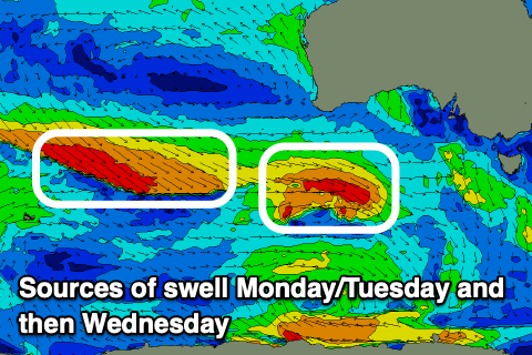
The source of swell down South will be a couple of healthy fronts moving in under the country through the weekend, with the first forming a small low pressure system to our south-west on Sunday.

This should produce a kick in mid-period SW swell Monday afternoon to 3ft+ across Middleton, easing from a similar size Tuesday but with fresh S/SE-S/SW winds, tending back S/SE late across the Mid Coast.
Tuesday looks better for the South Coast but not perfect as wind tip back E/NE during the morning as the swell eases.
Into Wednesday, a fun pulse of new SW groundswell is due, though not to the size expected earlier week.
This will be generated by a good frontal system generating W/NW gales to the south-west and then south of Western Australia on the weekend and this should come in at a good 3ft+ across Middleton again with 1-1.5ft sets across the Mid Coast.
Winds again look OK for both coasts and offshore inside the gulf with E/NE breezes down South ahead of sea breezes.
The end of the week then looks average with a return to S’ly winds Thursday with fading levels of swell, persisting Friday. More on this next week. Have a great weekend!

