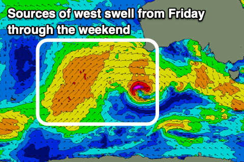
Plenty of west swell but with tricky winds
South Australian Forecast by Craig Brokensha (issued Wednesday September 4th)
Best Days: South Coast every day (afternoon tomorrow), Saturday Mid Coast, Tuesday and Wednesday Mid Coast
Features of the Forecast (tl;dr)
- Moderate sized, inconsistent W/SW groundswell building tomorrow, peaking PM, easing slowly Fri
- Gusty N/NE tending N winds inside the gulf tomorrow, more variable into the PM, strong N/NW tending variable down South
- Moderate sized W swell building Fri
- Dawn variable winds Fri, tending gusty W/SW, then easing
- Moderate + sized pulses of W/SW swell from Sat PM through Tuesday
- Light to moderate W/SW tending N/NW winds on the Mid Sat, W/NW down South
- Stronger W/NW winds Sun
- Fresh W/SW winds Mon (W/NW for a period down South)
- N/NE tending N/NW winds Tue
- Easing swell Wed with variable tending S/SW winds on the Mid, S/SE down South
Recap
Our large, reinforcing SW swell came in strong yesterday morning with 6ft to occasionally 8ft sets across the South Coast reefs under a light offshore wind. Conditions were a little lumpy but clean on the faces. The Mid Coast also saw good but slightly wind affected waves all day in the 2-3ft range.
This morning we’ve got less size but cleaner conditions down South with easing sets from 4ft, choppy and wind affected inside the gulf and to 2ft.
This week and next (Sep 5 - 13)
The coming period will consistent of various ebbs and pulses of west swell, with the timing of each pulse being a little fluid.
Thanks to the many swell generating fetches it makes it trickier to discern the coming energy, but in saying that, the Mid Coast will see fun pulses of swell from Friday through early next week, backing off slowly into the middle of next week. It’ll be the local winds that’ll be the main factor to work around.
Firstly, a new, inconsistent W/SW groundswell is due to build tomorrow, generated by a tight but strong low moving in from the Indian Ocean on the backside of all the activity that kicked off last week.
The Mid Coast looks to build to 1-2ft on the sets, while Middleton should come in around 3ft to occasionally 4ft into the afternoon. Gusty N/NE tending weaker N winds are due inside the gulf, with the South Coast seeing strong N/NW tending variable winds.
With this the afternoon might be the best option for both regions.

Into Friday, some new mid-period W/SW swell is due to arrive through the day, generated by a healthy fetch of strong W/SW-W winds under Western Australia today. This should boost the Mid Coast to a more consistent 2ft through the day, while Middleton looks to hold around an inconsistent 3ft to occasionally 4ft (more so into the afternoon)with a mix of swells.
Winds are tricky, with dawn variable breezes due to give into a gusty W/SW change, easing a little through the day, so the options for a clean wave will be very limited.
Saturday looks to be a similar size across both coasts, ahead of some new mid-period W/SW swell energy into the afternoon and Sunday.
This will be generated by a broad but not overly well aimed mid-latitude frontal progression pushing up towards Western Australia.
2-3ft sets should be seen across the Mid Coast into later Saturday but more so Sunday, with Middleton coming in around 3ft+.

On the backside of the progression pushing towards Western Australia, a stronger and further south located front should generate a stronger fetch of near gale-force W/SW winds through our western swell window. The front will weaken on approach and move through Saturday evening.
The swell from this stronger front is due Monday/Tuesday with fun, 2-3ft sets continuing inside the gulf on the favourable parts of the tide. Middleton looks to offer better 3-4ft surf from Monday through Tuesday, then easing Wednesday.
Local winds on Saturday look to linger from the W/SW across the Mid Coast, tending N/NW into the afternoon, with W/NW winds most of the day down South.
Unfortunately another frontal system moving through will bring strong W/NW winds on Sunday, with Monday seeing fresh W/SW winds in its wake (W/NW for a period down South).
Lighter winds are due Tuesday but still N/NE inside the gulf adding bumps, great down South.
It won’t be until Wednesday that winds possibly swing better offshore for the Mid Coast but this will be with smaller, fading surf.
So all in all, windows for the Mid Coast look limited for this run of swell.
Longer term the outlook looks a little more spring like with winds from the eastern quadrant but we’ll have a closer look at this on Friday.

