Plenty more west swell to come with windows for the Mid Coast
South Australian Forecast by Craig Brokensha (issued Monday September 2nd)
Best Days: Early tomorrow and into the afternoon Mid Coast, all day tomorrow South Coast, Wednesday South Coast, Thursday both coasts, Saturday morning both coasts, dawn Sunday both coasts
Features of the Forecast (tl;dr)
- Large mid-period W/SW-SW swell for this afternoon and early tomorrow, easing
- Early E/NE-NE tending moderate N/NE winds tomorrow across the Mid Coast, lighter N/NW-NW into the PM
- Moderate sized, inconsistent W/SW groundswell Thu with variable winds
- Strong W/NW tending W/SW winds Fri
- Moderate sized W/SW swell from Sat through Mon with local offshore tending sea breeze winds Sat, early variable tending strong W Sun
Recap
Solid, onshore surf across the Mid Coast all weekend with plenty of swell for the keen and experienced, while the South Coast offered some protection with large, building surf Saturday, peaking yesterday.
Today we’ve got a front passing through brining a renewal of solid, onshore surf across the Mid Coast, a little down on size from yesterday down South this morning but with less favourable winds and conditions. Winds have since shifted more W/SW along with some new swell on the build.
Also the Cape du Couedic wave buoy through up erroneous data on the weekend and will hopefully get a service, also fixing the erroneous swell direction readings from the past couple of months. The timeline on this may be quite a while though.
This week and weekend (Sep 3 - 8)
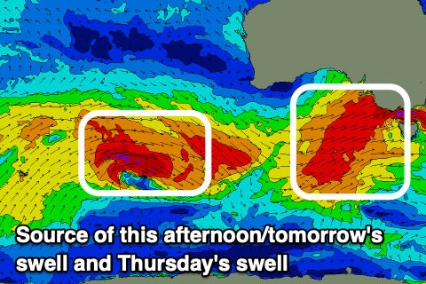
Today’s strong W/SW change is linked to another strong frontal system moving under us today, with it producing an additional spike in size this afternoon, with the period due to peak tomorrow morning.
This should result in a peak in size later today and early tomorrow to 6-8ft across Middleton with the Mid Coast seeing easing 3ft sets during the morning (2-3ft most of the day).

The main thing we’ve been waiting for inside the gulf are for winds to ease and swing offshore, with tomorrow being the day.
Early E/NE-NE winds will shift N/NE and increase to moderate, with lighter N/NW-NW winds into the afternoon, while the South Coast should see N/NW tending variable winds.
Wednesday will see the swell dropping to half the size of tomorrow morning along with strengthening N-N/NW winds (moderate to fresh early). With this the South Coast will be the pick over a choppy Mid Coast.
Into the late afternoon and more so Thursday, some less consistent reinforcing W/SW groundswell is due. It looks moderate in size, with the source being a small fetch of gale to severe-gale W/NW winds to the south-west of Western Australia.
This should boost the South Coast back to a less consistent 3-4ft across Middleton before easing Friday, with the Mid Coast hovering at an inconsistent 1-2ft.
Winds look funky on Thursday as a trough moves through with W/NW tending variable breezes likely, with at some stage them possibly swinging sea breezy.
Friday will then see strong W/NW-W/SW winds as the next swell generating front approaches.

This front will be the remnants of a stronger frontal system pushing up towards Western Australia over the coming days, with a moderate sized, mid-period W/SW swell being generated for Saturday/Sunday/Monday.
It should provide good, consistent 2ft sets from Saturday through Monday, with Middleton coming in at a slower 3ft or so (3-4ft Monday).
Winds on Saturday look favourable and local offshore ahead of sea breezes, with Sunday starting similarly but an approaching front will bring a strong W’ly change mid-morning.
Another swell producing front will bring the increasing winds and produce plenty more swell for early-mid week across the state as winds favour both coasts in general. More on this Wednesday.

