Good spike in swell tomorrow, fading into the rest of the week
South Australian Surf Forecast by Craig Brokensha (issued Monday June 24th)
Best Days: South Coast tomorrow and Wednesday
Features of the Forecast (tl;dr)
- Moderate-large sized SW swell tomorrow, peaking during the day with strong N/NW winds
- Rapidly easing swell Wed with gusty W/NW-NW winds
- Smaller and weak Thu/Fri with W/NW-NW winds Thu, N/NE Fri
- Small Sat with N/NW winds
- Mod-large sized S swell building Sun with strong SW-WSW winds, easing Mon with strong S winds
Recap
Small surf on Saturday for the keen across both coasts with the Mid’s swell from late in the week dropping back to 1-2ft, while a new pulse of SW groundswell for yesterday morning came in on cue with 2-3ft sets across Middleton under offshore winds.
Today the swell is fading with windier but clean conditions down South, sloppy in the gulf.
This week and weekend (Jun 25 - 30)
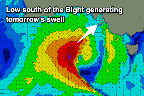
This week’s outlook revolves around a strong low that’s currently developed south of the Bight, south-west of us, with it due to linger over the coming days (strongest today) before shifting east and south of us later week.
As touched on last week, the low has a south to north orientation with most of the energy aimed towards the Eyre Peninsula, but we’re now expected to see a bit more energy aimed further east into our regions.
A tight fetch of gale to severe-gale S/SW winds will generate a moderate to large sized pulse of close-range SW swell that’s due to fill in tomorrow and peak through the middle of the day, easing quickly into Wednesday.

It’s a tricky one for the Mid Coast owing to the swell direction but 2-3ft sets are due tomorrow (mixed in with local windswell), fading from 2ft on Wednesday, with Middleton likely to pulse to 4-5ft, easing back from 3-4ft on Wednesday.
Unfortunately the Mid Coast will be poor and onshore with strong N/NW winds tomorrow, best down South with Wednesday seeing slightly weaker but still gusty NW winds, tending W/NW at times through the day.
Come the end of the week we’re looking at small levels of weak W/SW swell along with a W/NW-NW breeze down South Thursday, shifting N/NE into Friday as another mid-latitude low starts moving in from the west.
Now, at this stage this secondary low looks initially poor for swell generation across our region with it being focussed more into the Western Australian region, leaving no real swell for us until it moves further east and below us Saturday evening/Sunday.
We might see the low then stalling, generating some moderate to large, localised S’ly swell for Sunday/Monday but well have a closer look at this Wednesday.
The question is, with all this mid-latitude activity blocking up our main Southern Ocean swell window, when will we see a return to some proper frontal activity?
At this stage there’s no sign of it across our region but we should see increased activity to the south-west of Western Australia from next week, bringing some better but inconsistent W/SW groundswell energy from later next week. More on this in the coming updates.

