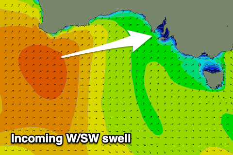
Good westerly swell inbound with dynamic but improving winds
South Australian Surf Forecast by Craig Brokensha (issued Wednesday June 19th)
Best Days: Tomorrow afternoon both regions, Friday both regions, Saturday morning both regions, South Coast Sunday and Monday
Features of the Forecast (tl;dr)
- Moderate + sized W/SW swell building later tomorrow, peaking Fri, easing Sat
- Strong N/NW tending N/NE winds, easing and tending more E later in the PM in the gulf
- SE-E/SE winds Fri AM (variable down South), ahead of moderate sea breezes
- Local offshore winds Sat with weak sea breezes
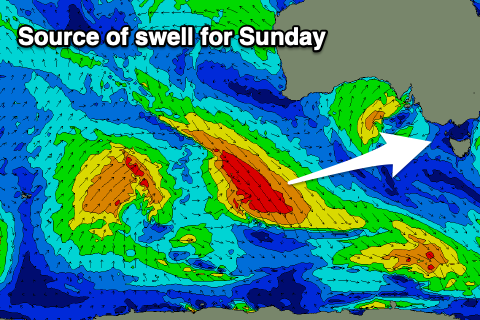
- Small-moderate sized SW swell for later Sat, peaking Sun AM, then easing
- Fresh N/NE winds Sun, fresh to strong Mon
Recap
The surf has been small and slow the last two days, clean down South but best across the magnets with tiny waves inside the gulf, increasing to 1-1.5ft today.
This week and next (Jun 20 - 28)
The days ahead revolve around the Mid Coast with a fun new W/SW swell due to fill in tomorrow afternoon, peaking through Friday.

The source has been a strong polar low projecting a fetch of W/SW gales towards and then under Western Australia while weakening.
The remnants of this system will move across us as a mid-latitude low tomorrow bringing funky but improving winds for the Mid Coast.
Strong N/NW breezes are due to shift N/NE and then E’ly into the late afternoon tomorrow as the swell kicks to the 2-3ft range, holding Friday with E/SE-SE offshore winds. The South Coast should see inconsistent 4ft sets on Friday as the swell peaks and with more variable winds through the morning.
The swell is due to ease back through the weekend with fun surf due across both regions Saturday under light, local offshore winds, and relatively weak sea breezes.

Later in the day Saturday but more so Sunday morning, a small pulse of new mid-period SW swell should be seen, generated by a healthy low moving into the Southern Ocean from the Indian Ocean while generating a fetch of strong to gale-force W/NW winds.
2-3ft waves are due across Middleton with 1ft sets continuing across the Mid Coast but with freshening N/NE winds, favouring the South Coast.
Following this there’s still nothing major on the cards at all thanks to funky mid-latitude systems continuing to meander in from the west. Winds look favourable for exposed breaks down South but that’s the best of it.
Therefore make the most of the coming swell.


Comments
Hey Craig, what are are your thoughts on the latest update on the Indian Ocean turning back to neutral IOD instead of positive in months ahead and what it means wave wise for south Australia?